
Mozakkir Azad 1*; Mahmud Afroz 2; Rajib Saha 3; Rojbe Rowshan 4; Mofassir Azad 5
1, Department of Environmental Science and Engineering, Jatiya Kabi Kazi Nazrul Islam University, Mymensingh-2220, Bangladesh
2, Department of Geosciences, University of Arkansas, Fayetteville, AR, 72701, USA
3, Department of Textile Engineering, Southeast University, Dhaka, Bangladesh
4, Department of Civil Engineering, Barisal Engineering College, Barisal, Bangladesh
5, Department of Applied Mathematics, University of Rajshahi, Rajshahi, Bangladesh
E-mail:
sabbirazad25@gmail.com
Received: 01/06/2025
Acceptance: 04/08/2025
Available Online: 05/08/2025
Published: 01/01/2026

Manuscript link
http://dx.doi.org/10.30493/DAS.2025.527660
Abstract
This research evaluates changes in land use and land cover, as well as vegetation dynamics in Rupganj, using Google Earth Engine and ArcGIS. For that purpose, land cover categories were classified utilizing supervised algorithms applied to multi-temporal Landsat TM and OLI imagery from the years 1994 and 2024. The classification accuracy attained was 86.75% for the 1994 imagery and 87.20% for the 2024 imagery. The analysis of land use and land cover change between 1994 and 2024 revealed significant increases in agricultural, vegetation, and urban areas (262.51%, 60.08%, and 12.96%, respectively). On the other hand, a notable decrease in barren lands and water bodies was observed (-46.12% and -42.11%, respectively). A substantial increase in NDVI values was recorded in 2024 relative to 1994, underscoring the enhanced vegetation health. The results highlight the patterns of urban growth, increased agricultural practices, reforestation initiatives, and changes in hydrological dynamics within the region. It is imperative to implement stringent measures aimed at safeguarding water resources, directing sustainable urban development, encouraging agro-ecological practices, and establishing green infrastructure as a standard practice. In this context, the integration of cloud-enabled monitoring facilitates adaptive and sustainable land management in the face of rapid peri-urban transformation.
Keywords: Land use land cover, NDVI, Remote sensing, Vegetation dynamics, Rupganj
Introduction
Changes in land use and land cover (LULC) serve as critical indicators of environmental and ecological dynamics, impacting both the landscape and the livelihoods of local communities as well as regional development [1][2]. In regions experiencing swift development, such as the Rupganj area in Bangladesh, these transformations carry significant consequences for sustainability, urban planning, and agricultural productivity [3]. The lack of foresight in urban growth and the expansion of agriculture result in unsustainable alterations in land utilization, subsequently impacting ecosystems, biodiversity, water resources, and the well-being of human populations [4]. Consequently, comprehending the spatial and temporal dynamics of land cover is crucial for tracking environmental changes, aiding urban planning, overseeing agricultural practices, and developing strategies for adapting to climate change [5].
Bangladesh, characterized by its high population density and growing urban areas, has undergone notable changes in land use and land cover in recent decades [6]. One area experiencing significant change is Rupganj, situated on the periphery of Dhaka [7]. Over time, Rupganj has transitioned from a predominantly agricultural and desolate area to a hybrid urban and peri-urban environment, characterized by rapid urban expansion and industrial development that exert growing pressure on the land [8]. The observed transformation has resulted in a decline of aquatic ecosystems and an increase in desolate terrains, alongside the expansion of urbanized and green spaces, frequently occurring without adequate foresight or regard for ecological impacts [9].
Remote Sensing (RS) and Geographic Information Systems (GIS) have emerged as essential methodologies for the analysis of land use and land cover changes across temporal scales. Satellite imagery provides reliable, extensive observation capabilities, while GIS facilitates the analysis of spatial data [10]. The Normalized Difference Vegetation Index (NDVI) serves as a critical metric for assessing vegetation health and density, offering significant insights into the effects of urbanization, agricultural expansion, and climate change. Derived from red and near-infrared reflectance, NDVI functions as a reliable indicator of vegetation health and biomass [11][12]. The incorporation of cloud-based platforms such as Google Earth Engine (GEE) has significantly improved the capacity to process and analyze extensive datasets of satellite imagery with efficiency [13]. Consequently, these tools are extremely valuable in assessing LULC dynamics in regions with complex and diverse nature.
In comparison to other peri-urban areas surrounding Dhaka, including Savar and Gazipur, Rupganj stands out due to its advantageous location along key transportation routes and its participation in various government-sponsored industrial development programs [14]. In examining the developmental trajectories of Savar, Gazipur, and Rupganj, it is evident that Savar’s growth has primarily been driven by the establishment of educational institutions and light industries. In contrast, Gazipur’s expansion is largely attributed to the proliferation of garment factories and suburban development. Rupganj, however, presents a distinct case with its concentrated mixed-use development, which encompasses heavy industry, residential areas, and commercial centers [15]. This positions Rupganj as a significant buffer zone and a focal point for land transformation, characterized by elevated rates of vegetation loss and land conversion, distinguishing it from comparable peri-urban areas in Bangladesh [16].
Although there is an increasing amount of research regarding changes in land use and land cover in Bangladesh, the majority of investigations have focused on prominent urban areas such as Dhaka, Chattogram, and Khulna [17]. These investigations frequently neglect peri-urban areas—regions that exist in a transitional state between urban and rural, yet are undergoing swift changes as a result of urban expansion [18]. Rupganj, situated on the periphery of Dhaka, represents an area undergoing significant transformations in land utilization [19]. Nonetheless, a significant gap exists in the body of research concerning long-term, satellite-based investigations that evaluate land use and vegetation dynamics within this region [20][21]. Therefore, a comprehensive spatial analysis is needed to comprehend the evolution of peri-urban areas like Rupganj over prolonged durations.
Based on the previously discussed research gap, this research seeks to assess and measure the enduring alterations in land use and vegetation within Rupganj over the period from 1994 to 2024, employing remote sensing and GIS methodologies. The primary aims consist of delineating spatial patterns associated with urban growth, evaluating the degree of vegetation cover reduction, and monitoring the transformation of agricultural land into developed and industrial areas. This study employs multi-temporal satellite imagery analysis to identify trends and rates of change, providing insights that can enhance sustainable urban planning, environmental management, and policy formulation. The results are intended to bolster sustainable development and promote environmental conservation in Rupganj and similar rapidly evolving areas.
Materials and Methods
Study area
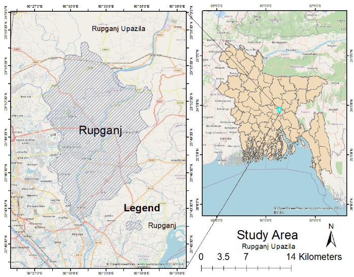
Rupganj, located in the Narayanganj District in central Bangladesh, spans an area of approximately 275.96 square kilometers [22]. The study area lies roughly between 23.70°N to 23.85°N latitude and 90.60°E to 90.80°E longitude (Fig. 1), positioned on the eastern periphery of Dhaka city [23][24]. This region is characterized by a diverse landscape that includes flowing rivers, fertile agricultural lands, dense vegetation, urban settlements, and barren or uncultivated fields [25-27]. Traditionally known for its agricultural productivity and natural resources, Rupganj has undergone significant transformations over recent decades due to its proximity to Dhaka [27]. This proximity has accelerated urban expansion, industrial growth, and infrastructural development, resulting in rapid population increase and changes in land use patterns [28][29]. As a result, Rupganj has transformed from a predominantly rural area to a dynamic peri-urban industrial hub [30]. The establishment of numerous factories, residential complexes, and transport infrastructure has shifted Rupganj from a primarily rural and agrarian landscape to a mixed peri-urban and industrialized zone [31].
Data sources
For this study, satellite imagery from Landsat platforms was utilized to assess land use and land cover (LULC) changes in Rupganj over the period from 1994 to 2024. Landsat 5 Thematic Mapper (TM) imagery for 1994 and Landsat 8 Operational Land Imager (OLI) imagery for 2024 were acquired from the USGS Earth Explorer platform [32]. To minimize phenological bias and ensure temporal comparability, all images were selected from the dry season (typically November to February) for both years [33]. A strict cloud cover threshold of less than 5% was applied to guarantee high-quality, cloud-free data suitable for reliable analysis [34]. Preprocessing steps included radiometric correction, atmospheric correction using the Dark Object Subtraction (DOS) method implemented in Google Earth Engine (GEE), and geometric rectification performed with ArcGIS and GEE to ensure spatial alignment and accuracy [35][36]. Subsets of the imagery corresponding to the Rupganj boundary were extracted using shape files to focus the analysis on the study area. Additionally, ground truth data was collected through field surveys and high-resolution images to support the classification accuracy of land cover types [20][37]. These combined data sources and preprocessing methods enabled precise LULC classification and NDVI calculations for assessing long-term vegetation and land use dynamics in Rupganj [20][38].
Accuracy assessment of classified images
Land use and land cover classification was performed using a supervised Random Forest (RF) classifier implemented within Google Earth Engine (GEE) [39]. The Random Forest algorithm was chosen for its high accuracy and robustness in remote sensing applications [40]. A total of 200 ground truth points were used to train the classifier, selected through a combination of field surveys and interpretation of high-resolution satellite imagery [41]. These points were carefully distributed across the study area to represent all major land cover classes, including water bodies, built-up areas, vegetation, agricultural land, and barren areas [42]. To ensure methodological consistency, the same field teams and classification criteria were applied for data collection and validation across both 1994 and 2024 datasets. For 1994, where direct field data were limited, historical high-resolution imagery and ancillary data sources supplemented the ground truth dataset for training and validation purposes.
Accuracy assessment is an important part of any classification project that compares the classified image to another data source that is considered to be accurate or ground truth data [43]. Ground truth can be collected in the field or can be derived from interpreting high-resolution imagery, existing classified imagery, or GIS data layers [44]. Producer’s accuracy refers to the accuracy of a map from the perspective of the mapmaker, or producer [45]. It measures how often real-world features are correctly represented in the classified map or the likelihood that a particular land cover class is accurately identified [46]:

To calculate user’s accuracy for a specific class, the number of correctly classified pixels in that class is divided by the total number of pixels classified in that class, including both correct and incorrect classifications [45]:

Overall accuracy provides a measure of the classification accuracy for the entire image, covering all classes present in the classified map. It represents the collective accuracy by calculating the proportion of correctly classified pixels across all land cover classes, offering a comprehensive assessment of the map’s overall performance [47]:
The kappa statistic is a measure of agreement between the classified data and the reference data, with values ranging from -1 to 1. It is often multiplied by 100 to express classification accuracy as a percentage [48]. These values can be categorized into three groups: (1) greater than 0.80 indicates strong agreement, (2) between 0.40 and 0.80 reflects moderate agreement, and (3) less than 0.40 suggests poor agreement between the classification and reference data. The Kappa co-efficient (K) is calculated using the following equation [49]:
NDVI estimation and cross-sensor calibration
For each study year, vegetation characteristics such as NDVI were estimated using ArcGIS 10.8 to assess the vegetation areas [50]. To ensure comparability of NDVI values across sensors with different spectral characteristics and sensitivities, a cross-sensor calibration procedure was implemented following established methodologies [51]. This involved applying spectral adjustment coefficients derived from sensor spectral response functions and using atmospheric correction algorithms to normalize reflectance values [52]. Imagery from the same dry season (November to February) was used for both years to minimize phenological differences [53]. Atmospheric correction was performed by using the Landsat surface reflectance products available in Google Earth Engine (GEE), which apply standardized correction algorithms (such as LEDAPS for Landsat 5 and LaSRC for Landsat 8) to reduce atmospheric scattering and absorption effects [54]. NDVI is estimated using the following equation [49]:
Where:
NIRis the near-infrared band (which measures vegetation reflectance)
Redis the red band (which is sensitive to chlorophyll absorption).
The NDVI values range from -1 to +1, where negative values typically represent non-vegetated surfaces (such as barren land or water), while positive values indicate varying levels of vegetation [55]. Higher NDVI values suggest dense, healthy vegetation, and lower values correspond to sparse or stressed vegetation [56]. To validate NDVI-based vegetation assessments, spatial comparisons were made with available field vegetation surveys and high-resolution vegetation maps collected during the study period [57]. This spatial validation confirmed the reliability of NDVI trends detected via satellite data.
Results
Land use and land cover changes
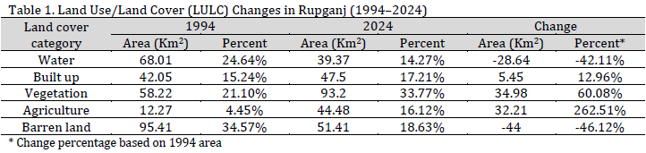
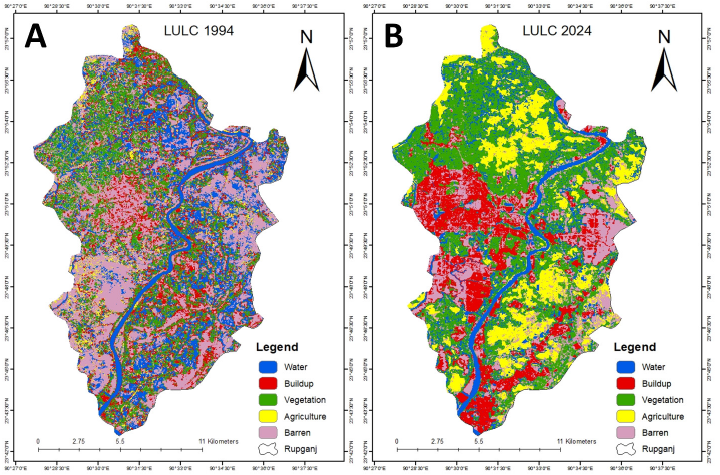
The Rupganj region has experienced notable and complex changes in land use and land cover between 1994 and 2024 (Fig. 2 and Table 1). during this three-decade period, a significant decrease in barren land was recorded, shrinking from 95.41 km² (34.57% of the total area) to 51.41 km² (18.63%), indicating a reduction of approximately 46% in this category. This decrease illustrates the impact of proactive land reclamation initiatives, urban expansion, and the transformation of less productive areas into viable agricultural or residential spaces, suggesting a general enhancement in land productivity and usage.
The area of water bodies has undergone a significant reduction, decreasing from 68.01 km² (24.64%) in 1994 to 39.37 km² (14.27%) in 2024. The observed decline can be linked to several contributing elements, such as the reclamation of land for the expansion of urban and agricultural zones, the diversion of water resources for industrial and domestic purposes, and potential hydrological alterations driven by both natural phenomena and human activities. The reduction of aquatic surfaces prompts significant apprehensions regarding the sustainability of regional water resources and the overall sustainability of ecosystems.
On the other hand, there was a significant expansion of vegetation cover, which expanded from 58.22 km² (21.10%) in 1994 to 93.20 km² (33.77%) in 2024. The observed increase reflects the effectiveness of afforestation and reforestation efforts, as well as the implementation of green infrastructure initiatives by local authorities and communities. The increasing vegetation cover serves as an indicator of enhanced environmental conditions, as well as a testament to the rising consciousness and initiatives aimed at ecological preservation and sustainable land management within the area.
Similarly, agricultural land demonstrated a notable relative increase, expanding from 12.27 km² (4.45%) to 44.48 km² (16.12%), reflecting a 262.51% growth. This increase highlights the growing demand for food production to accommodate the region’s surging population and urban development. The adoption of contemporary agricultural practices, the transformation of previously unproductive lands, and the expansion of farming areas into peri-urban regions have significantly influenced this trend.
The extent of built-up areas, indicative of urban growth and infrastructure advancement, experienced a moderate increase from 42.05 km² (15.24%) in 1994 to 47.50 km² (17.21%) in 2024. Despite the relatively modest increase in urbanized areas in 2024 compared to 1994, built-up areas appear more concentrated and organized in 2024 observations (Fig. 2). This organized urbanization (mainly represented by Purbachal New Town Project in the center) is influenced by demographic expansion, industrial progress, and the necessity for housing. The observed increase, though seemingly modest in comparison to other categories, nonetheless indicates an ongoing transition from a primarily rural setting to a more urbanized and industrial landscape.
The observed land use and land cover changes depict Rupganj’s evolution from a predominantly rural and desolate environment in 1994 to a more varied land use configuration by 2024, marked by the proliferation of vegetation, agricultural activities, and urban development, coupled with a reduction in water bodies and barren terrain. The observed shifts underscore the intricate interactions between natural phenomena and anthropogenic influences, encompassing policy-oriented land management, urban development strategies, and socio-economic progress.
NDVI trends and vegetation health
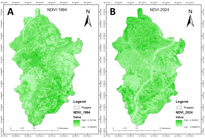
NDVI analysis corroborates the LULC alterations, indicating a significant enhancement in vegetation density and vitality throughout the 30-year span. The NDVI range transitioned from -0.295 to 0.161 in 1994 (Fig. 3 A), signifying sparse vegetation, to -0.089 to 0.491 in 2024 (Fig. 3 B), indicating enhanced and more robust vegetation cover. This greening tendency is highly correlated with the increased vegetation and agricultural regions identified in the classification. In 2024, the highest NDVI values are observed in the northern and southern agricultural regions, and the central urban area exhibits a generally low NDVI value.
Classification accuracy
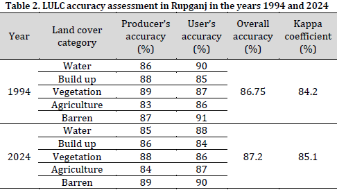
The classification model’s robustness is validated by the accuracy evaluations (Table 2). The overall accuracy increased marginally from 86.75% in 1994 to 87.20% in 2024, and the Kappa coefficient rose from 84.20% to 85.10%, indicating substantial reliability. The producer’s and user’s accuracies for individual land cover class typically exceeded 80%, hence confirming the classification outcomes and instilling confidence in the identified spatial and temporal land use and land cover changes.
Discussion
The land use and land cover (LULC) alterations in Rupganj over the last 30 years demonstrate a swift and complex shift predominantly influenced by urbanization, population increase, and agricultural development [18][21]. These alterations have significant consequences for the region’s sustainability, especially considering its status as a peri-urban area on the periphery of Dhaka, one of South Asia’s rapidly expanding megacities [24][58].
The decrease in barren land—from 34.57% in 1994 to 18.63% in 2024—underscores a transition towards more productive land applications, including agriculture and urban development. This shift indicates a rising land utilization necessary to satisfy the demands of a burgeoning population. The escalation of land utilization, especially in agriculture and urban sectors, prompts apprehensions over land degradation, biodiversity decline, and the excessive exploitation of natural resources. The transformation of unproductive land is advantageous for development; however, it requires meticulous management to prevent adverse environmental consequences, including soil erosion, depletion of ecosystem services, and decline in local biodiversity. The substantial decline in water bodies—from 24.64% in 1994 to 14.27% in 2024—illustrates the impacts of urban expansion and land reclamation, resulting in the transformation of water supplies for developmental activities. This decline raises concerns over water scarcity, diminished biodiversity in aquatic environments, and potential disturbance of the local hydrological cycle. Prioritizing the protection of existing water bodies (represented mainly by Shitalakshya River) is essential in future urban design to ensure the resilience of local ecosystems and the sustainable management of water resources. The increase in vegetation cover area signifies the efficacy of afforestation initiatives and the heightened implementation of green infrastructure. This augmentation is essential for urban resilience, as it improves air quality, offers cooling benefits in urban heat islands, and aids with carbon sequestration. This trend corresponds with global sustainability objectives that highlight the significance of green spaces in alleviating the detrimental impacts of urbanization and climate change. The increase in agricultural land areas signifies the rising requirement for food production to support the expanding population. However, this growth must be undertaken cautiously, as it may result in more loss of natural ecosystems and exert pressure on local water resources.
Numerous studies in peri-urban regions of Bangladesh and elsewhere showed similar patterns of urban expansion and agricultural intensification due to rapid population growth [59]. However, in areas adjacent to Dhaka, such as Gazipur and Savar, urban expansion has resulted in the depletion of agricultural land and vegetative cover [60]. Rupganj exemplifies a distinctive scenario owing to its amalgamation of agricultural expansion, industrial development, and afforestation initiatives [61]. In contrast to other peri-urban zones, this area has experienced substantial vegetation growth attributable to effective reforestation initiatives, diverging from the prevalent trend of vegetation loss in other fast urbanizing locales [62][63]. These disparities underscore the necessity of formulating customized land management plans that consider the distinct socio-economic and ecological circumstances of each location [23][64].
Although research from several regions underscores the adverse impacts of urbanization on local ecosystems, Rupganj uniquely exemplifies a concurrent trend of agricultural intensification and ecological restoration [65]. Effective planning and regulatory frameworks can simultaneously achieve urban expansion and environmental sustainability [66][67]. This study’s findings underscore the necessity for balanced and integrated land management techniques in Rupganj to foster sustainable development [68]. Although urbanization and agricultural expansion are unavoidable in peri-urban regions, these developments must be harmonized with environmental conservation initiatives to guarantee sustainable progress [69]. The growth of urban areas must be regulated to mitigate the environmental effects on aquatic systems and ecosystems [4]. Implementing green infrastructure, including urban parks and permeable surfaces, can alleviate the impacts of urban sprawl [59]. On the other hand, the reduction of water bodies requires immediate strategies to protect water resources, such as wetland restoration, regulation of urban water usage, and investment in water conservation technologies [70]. Policies must facilitate the adoption of climate-resilient crops and optimize water use to reduce agriculture’s ecological footprint [64]. The observed favorable trend in vegetation cover should be bolstered by ongoing afforestation initiatives and the planned establishment of green spaces in urban environments, thus augmenting ecological resilience and boosting inhabitants’ quality of life [71].
Notwithstanding the thoroughness of this investigation, various limitations must be acknowledged while analyzing the data. A constraint is the temporal resolution of Landsat images, which captures land use and land cover changes at a decadal scale. Increased frequency of satellite data or enhanced resolution imagery could elucidate intra-annual fluctuations in land use and vegetation dynamics [48]. The study predominantly utilized remote sensing data and NDVI analysis, which, while significantly beneficial, may neglect more nuanced dynamics and local variances in land use change [44]. Subsequent research should integrate field surveys and socioeconomic data to enhance understanding of the factors influencing land-use change and its wider effects on local communities [27].
The alterations in land use and vegetation in Rupganj from 1994 to 2024 demonstrate a multifaceted interaction between urbanization, agricultural growth, and ecological preservation. The region has experienced significant changes, although the favorable developments in vegetation cover and agricultural land growth indicate the potential for sustainable development in swiftly urbanizing areas. It is imperative to implement integrated land management measures that promote both development and environmental conservation, ensuring that Rupganj’s expansion is robust, sustainable, and ecologically balanced.
Conclusion
This study provides a detailed assessment of the land use and land cover (LULC) changes in Rupganj, Bangladesh, over the past 30 years. The findings reveal significant shifts in the landscape, including a notable reduction in barren land, an increase in vegetation cover and agricultural land, and a decline in water bodies. These transformations reflect a growing demand for land to accommodate urban and agricultural expansion, driven by population growth, industrialization, and government-led infrastructure development. The results underscore the importance of integrated land management strategies that balance urban growth with ecological conservation. The decline in water bodies is particularly concerning, highlighting the need for urgent measures to protect and restore aquatic ecosystems, which are vital for sustaining local biodiversity and water resources. Given the rapid transformations observed in Rupganj, future research should focus on incorporating higher-resolution satellite imagery for more detailed monitoring of land use changes, as well as socio-economic data to understand the underlying drivers of these changes.
Conflict of interest statement
The authors declared no conflict of interest.
Funding statement
The authors declared that no funding was received in relation to this manuscript.
Data availability statement
The authors declared that all used data and data sources are mentioned in the manuscript. All datasets will be available upon reasonable request from the corresponding author.
References
- Sresto MA, Siddika S, Fattah MA, Morshed SR, Morshed MM. A GIS and remote sensing approach for measuring summer-winter variation of land use and land cover indices and surface temperature in Dhaka district, Bangladesh. Heliyon. 2022;8(8). DOI
- Khan Z, Khalid W, Ali SA, Shamim SK, Ahmad A. Analysing the potential impacts of land use land cover (LULC) transformation on present and future carbon sequestration capabilities in the central Himalayas. Discov. Geosci. 2024;2(1):92. DOI
- Wang L, Sarker PK. Analyzing urban sprawl and sustainable development in Dhaka, Bangladesh. J. Econ. Sustain. Dev. 2020;11(6):2222-1700. DOI
- Saha J, Ria SS, Sultana J, Shima UA, Seyam MM, Rahman MM. Assessing seasonal dynamics of land surface temperature (LST) and land use land cover (LULC) in Bhairab, Kishoreganj, Bangladesh: A geospatial analysis from 2008 to 2023. Case Stud. Chem. Environ. Eng. 2024;9:100560. DOI
- Alongi DM. Mangrove forests: resilience, protection from tsunamis, and responses to global climate change. Estuar. Coast. Shelf Sci. 2008;76(1):1-3. DOI
- Islam MA, Maitra MK, Majlis AK, Rahman S. Spatial changes of land use/land cover of Moheshkhali Island, Bangladesh: a fact finding approach by remote sensing analysis. Dhaka Univ. J. Earth Environ. Sci. 2012;2:43-54.
- Gemeda DO, Kerbe TA, Gemechu HW. Land use land cover change and public perceptions differently affect black crowned crane (Balearica pavonina) conservation: Evidences from Jimma zone southwestern Ethiopia. Environ. Sustain. Indic. 2023;19:100288. DOI
- Isufi F, Berila A. Using geospatial technology to analyse land use/cover changes in Prishtina, Kosovo (2000–2020). GeoJournal. 2022;87(5):3639-53. DOI
- Bunyangha J, Majaliwa MJ, Muthumbi AW, Gichuki NN, Egeru A. Past and future land use/land cover changes from multi-temporal Landsat imagery in Mpologoma catchment, eastern Uganda. Egypt. J. Remote Sens. Space Sci. 2021;24(3):675-85. DOI
- Kafy AA, Shuvo RM, Naim MN, Sikdar MS, Chowdhury RR, Islam MA, Sarker MH, Khan MH, Kona MA. Remote sensing approach to simulate the land use/land cover and seasonal land surface temperature change using machine learning algorithms in a fastest-growing megacity of Bangladesh. Remote Sens. Appl. Soc. Environ. 2021;21:100463. DOI
- Kanjin K, Alam BM. Assessing changes in land cover, NDVI, and LST in the Sundarbans mangrove forest in Bangladesh and India: A GIS and remote sensing approach. Remote Sens. Appl. Soc. Environ. 2024;36:101289. DOI
- Rashid MB, Sheik MR, Haque AE, Siddique MA, Habib MA, Patwary MA. Salinity-induced change in green vegetation and land use patterns using remote sensing, NDVI, and GIS techniques: A case study on the southwestern coast of Bangladesh. Case. Stud. Chem. Environ. Eng. 2023;7:100314. DOI
- Gulshan J, Chowdhury RI, Islam MA, Akhter HH. GEE models for maternal morbidity in rural Bangladesh. Aust. J. Stat. 2005;34(3):295-304. DOI
- Abdullah HM, Islam I, Miah MG, Ahmed Z. Quantifying the spatiotemporal patterns of forest degradation in a fragmented, rapidly urbanizing landscape: A case study of Gazipur, Bangladesh. Remote Sens. Appl. Soc. Environ. 2019;13:457-65. DOI
- Hassan MM, Southworth J. Analyzing land cover change and urban growth trajectories of the mega-urban region of Dhaka using remotely sensed data and an ensemble classifier. Sustainability. 2017;10(1):10. DOI
- Muhsin N, Ahamed T, Noguchi R. GIS-based multi-criteria analysis modeling used to locate suitable sites for industries in suburban areas in Bangladesh to ensure the sustainability of agricultural lands. Asia Pac. J. Reg. Sci. 2018;2(1):35-64. DOI
- Rahman MM, Szabó G. Impact of land use and land cover changes on urban ecosystem service value in Dhaka, Bangladesh. Land. 2021;10(8):793. DOI
- Al-Dousari AE, Mishra A, Singh S. Land use land cover change detection and urban sprawl prediction for Kuwait metropolitan region, using multi-layer perceptron neural networks (MLPNN). Egypt. J. Remote Sens. Space Sci. 2023;26(2):381-92. DOI
- Sajib AM, Moniruzzaman M. Driving forces of landuse and landcover changes in the north-eastern part of Dhaka Conurbation. Dhaka Univ. J. Earth Environ. Sci. 2021;10(2):53-66. DOI
- Haque SMN, Uddin ASMS. Identifying land use land cover change using google earth engine: a case study of Narayanganj district, Bangladesh. Theor. Appl. Climatol. 2025;156(2). DOI
- Afzal I, Waseem LA, Khurshid M, Maqbool MS. Spatio-Temporal Changes in Patterns of Land Use and Land Cover in Peri-Urban Areas of Faisalabad City. Pak. J. Humanit. Soc. Sci. 2023;11(3):3027-37. DOI
- Noman AH, Mia MA, Banna H, Rana MS, Alam AF, Gee CS, Isa CR, Er AC. City profile: Narayanganj, Bangladesh. Cities. 2016;59:8-19. DOI
- Azad M, Azad M, Haque IS, Ahmed MM. GIS-Based Spatial Analysis of Sustainable Supply Chain Practices in the Textile Industry: A Case Study of Narayanganj’s Dyeing Sector. In 3rd International Conference on Textile Science and Engineering (ICTSE 2025) with special focus on Fashion Innovation and Sustainable Apparel Production. BUTEX, Dhaka, Bangladesh. 2025.
- Begum MS, Bala SK, Islam AS, Islam GT, Roy D. An analysis of spatio-temporal trends of land surface temperature in the Dhaka metropolitan area by applying landsat images. J. Geogr. Inf. Syst. 2021;13(4):538-60. DOI
- Hasan MM, Rana MS, Ferdous MT. Prediction of Groundwater Potential Zone Using Machine Learning and Geospatial Approaches for an Industry-Dominated Area in Narayanganj, Bangladesh. J. Indian Soc. Remote Sens. 2025:1-7. DOI
- Majumder A, Hossain T, Rahman M, Mita M, Hossain S. Spatial Distribution of Air Quality in Narayanganj District Town, Bangladesh. Am. J. Environ. Prot. 2025;14(2):21–35. DOI
- Theodosiou G, Panajiotidis S. The impact of urban land-use regimes on the stream vegetation and quality of a Mediterranean City. Hydrology. 2023;10(2):45. DOI
- Haydar M, Hosan S. Assessment of urban expansion susceptibility in major urban units of Bangladesh leveraging machine learning and geostatistical approach. J. Urban Manag. 2024;14(2):451-67. DOI
- Hoque A, Mohiuddin M, Su Z. Effects of industrial operations on socio-environmental and public health degradation: evidence from a least developing country (LDC). Sustainability. 2018;10(11):3948. DOI
- Aktar M. Public investments in large urban projects: Reassessment from Land Value Capture perspective in Dhaka, the capital city of Bangladesh. J. Bangladesh Inst. Plan. 2024;17(1). DOI
- Rahman MA, Islam KS, Siam SI, Islam S. Spatiotemporal change of land use land cover: A case study of narayanganj sadar upazila, bangladesh. Khulna Univ. Stud. 2022:233-43. DOI
- Galata AW. Analysis of land use/land cover changes and their causes using landsat data in hangar watershed, Abay basin, Ethiopia. J. Sediment. Environ. 2020;5(4):415-23. DOI
- Abbas Z, Yang G, Zhong Y, Zhao Y. Spatiotemporal change analysis and future scenario of LULC using the CA-ANN approach: A case study of the greater bay area, china. Land. 2021;10(6):584. DOI
- Zhong B, Chen W, Wu S, Hu L, Luo X, Liu Q. A cloud detection method based on relationship between objects of cloud and cloud-shadow for Chinese moderate to high resolution satellite imagery. IEEE J. Sel. Top. Appl. Earth Obs. Remote Sens. 2017;10(11):4898-908. DOI
- Frantz D, Röder A, Stellmes M, Hill J. An operational radiometric Landsat preprocessing framework for large-area time series applications. IEEE Trans. Geosci. Remote Sens. 2016;54(7):3928-43. DOI
- Ansari M, Knudby A, Amani M, Sawada M. Retrieving Inland Water Quality Parameters via Satellite Remote Sensing: Sensor Evaluation, Atmospheric Correction, and Machine Learning Approaches. Remote Sens. 2025;17(10):1734. DOI
- Byomkesh T, Nakagoshi N, Dewan AM. Urbanization and green space dynamics in Greater Dhaka, Bangladesh. Landsc. Ecol. Eng. 2012;8(1):45-58. DOI
- Seyam MM, Haque MR, Rahman MM. Identifying the land use land cover (LULC) changes using remote sensing and GIS approach: A case study at Bhaluka in Mymensingh, Bangladesh. Case Stud. Chem. Environ. Eng. 2023;7:100293. DOI
- Karmakar S, Rahman M, Meng L. Land Cover Changes and Land Surface Temperature Dynamics in the Rohingya Refugee Area, Cox Bazar, Bangladesh: An Analysis from 2013 to 2024. Atmosphere. 2025;16(3):250. DOI
- Belgiu M, Drăguţ L. Random forest in remote sensing: A review of applications and future directions. ISPRS J. Photogramm. Remote Sens. 2016;114:24-31. DOI
- Chowdhury MS. Comparison of accuracy and reliability of random forest, support vector machine, artificial neural network and maximum likelihood method in land use/cover classification of urban setting. Environ. Challenges. 2024;14:100800. DOI
- Bento VA, Trigo IF, Gouveia CM, DaCamara CC. Contribution of land surface temperature (TCI) to vegetation health index: A comparative study using clear sky and all-weather climate data records. Remote Sens. 2018;10(9):1324. DOI
- Nicolau AP, Dyson K, Saah D, Clinton N. Accuracy assessment: Quantifying classification quality. In Cloud-Based Remote Sensing with Google Earth Engine: Fundamentals and Applications. Cham: Springer International Publishing. 2023:135-45. DOI
- Abbas Z, Jaber HS. Accuracy assessment of supervised classification methods for extraction land use maps using remote sensing and GIS techniques. In IOP conference series: materials science and engineering. Iop Publishing. 2020;745(1):012166. DOI
- Ye S, Pontius Jr RG, Rakshit R. A review of accuracy assessment for object-based image analysis: From per-pixel to per-polygon approaches. ISPRS J. Photogramm. Remote Sens. 2018;141:137-47. DOI
- Foody GM. Harshness in image classification accuracy assessment. Int. J. Remote Sens. 2008;29(11):3137-58. DOI
- Rwanga SS, Ndambuki JM. Accuracy assessment of land use/land cover classification using remote sensing and GIS. Int. J. Geosci. 2017;8(04):611. DOI
- Berdimbetov T, Ilyas S, Ma Z, Bilal M, Nietullaeva S. Climatic change and human activities link to vegetation dynamics in the Aral Sea Basin using NDVI. Earth Syst. Environ. 2021;5(2):303-18. DOI
- Khan A, Alamgir A, Fatima N. Spatiotemporal analysis of land use and land cover changes, LST and NDVI in Thatta district, Sindh, Pakistan. Kwt. J. Sci. 2025;52(1):100326. DOI
- Gandhi GM, Parthiban S, Thummalu N, Christy A. Ndvi: Vegetation change detection using remote sensing and gis–A case study of Vellore District. Procedia Comput. Sci. 2015;57:1199-210. DOI
- Sun Y, Wang B, Teng S, Liu B, Zhang Z, Li Y. Continuity of Top-of-Atmosphere, Surface, and Nadir BRDF-Adjusted Reflectance and NDVI between Landsat-8 and Landsat-9 OLI over China Landscape. Remote Sens. 2023;15(20):4948. DOI
- Cundill SL, van der Werff HM, Van der Meijde M. Adjusting spectral indices for spectral response function differences of very high spatial resolution sensors simulated from field spectra. Sensors. 2015;15(3):6221-40. DOI
- Claverie M. Evaluation of surface reflectance bandpass adjustment techniques. ISPRS J. Photogramm. Remote Sens. 2023;198:210-22. DOI
- Wang Y, Liu L, Hu Y, Li D, Li Z. Development and validation of the Landsat-8 surface reflectance products using a MODIS-based per-pixel atmospheric correction method. Int. J. Remote Sens. 2016;37(6):1291-314. DOI
- Ozyavuz M, Bilgili BC, Salici AY. Determination of vegetation changes with NDVI method. J. Environ. Prot. Ecol. 2015;16(1):264-73.
- Johansen B, Tømmervik H. The relationship between phytomass, NDVI and vegetation communities on Svalbard. International Journal of Applied Earth Observation and Geoinformation. 2014;27:20-30. DOI
- Singh P, Javeed O. NDVI based assessment of land cover changes using remote sensing and GIS (A case study of Srinagar district, Kashmir). Sustain. Agri. Food Environ. Res. 2021;9(4):491-504. DOI
- Ahammed F, Hewa GA, Argue JR. Variability of annual daily maximum rainfall of Dhaka, Bangladesh. Atmos. Res. 2014;137:176-82. DOI
- Sultana N, Sharifi A, Haque MN, Aghaloo K. Urban greening in Dhaka: Assessing rooftop agriculture suitability using GIS and MCDM techniques. J. Environ. Manage. 2024;368:122146. DOI
- al Mahmud A, Sultana N, Habib ME. Application of GIS for Spatio-Temporal Modeling of Land Use Change and Environmental Degradation in Dhaka, Narayanganj, and Gazipur: A 24-Year Study (1999–2023). Researchsquare preprint. 2024. DOI
- Sahoo A, Subhadarshini R, Baliarsingh F. Mapping of groundwater potential zones of Khordha District using GIS and AHP approaches. Clean. Water. 2024;1:100015. DOI
- Islam S, Karipot A, Bhawar R, Sinha P, Kedia S, Khare M. Urban heat island effect in India: a review of current status, impact and mitigation strategies. Discov. Cities. 2024;1(1):34. DOI
- Salah A, Liu X, Tareke KM, Azad M, Fikru FA. The impact of climate change and climate variability on the pastoralist communities in Moyle District, Somali Regional State, Ethiopia. Open access Libr. J. 2024;11(5). DOI
- Candraningtyas CF, Arfiantinosa N, Matin HH, Azad M. Environmental Impact Analysis in the Cement Industry with Life Cycle Assessment Method. J. Ecol. Eng. 2024;25(6):258-70. DOI
- Hossain MM, Jahan I, Al Nahian A, Johannesson KH, Maxwell SJ, Zhu D. Distribution of potentially toxic elements in sediments of the municipal river channel (Balu), Dhaka, Bangladesh: Ecological and health risks assessment. J. Contam. Hydrol. 2025;269:104492. DOI
- Ahmed Z, Alam R, Akter SA, Kadir A. Environmental sustainability assessment due to stone quarrying and crushing activities in Jaflong, Sylhet. Environ. Monit. Assess. 2020;192(12):778. DOI
- Bhuiyan MR, Mamur H, Begum J. A brief review on renewable and sustainable energy resources in Bangladesh. Clean. Eng. Technol. 2021;4:100208. DOI
- Badruddin A. Sustainable low-carbon post COVID 19 recovery measures across sectors in world economies: a thematic analysis on its coverage. Total Environ. Res. Themes. 2023;6:100045. DOI
- Dewan AM, Kabir MH, Nahar K, Rahman MZ. Urbanisation and environmental degradation in Dhaka Metropolitan Area of Bangladesh. Int. J. Environ. Sustain. Dev. 2012;11(2):118-47. DOI
- Anjali R, Krishnakumar S, Thivya C, Kasilingam K, Suresh Gandhi M, Selvakumar S, Satheesh Herbert Singh D, Magesh NS. Assessment of mine water quality for domestic and irrigation purposes, Neyveli coal mine region, Southern India. Total Environ. Res. Themes. 2023;6:100047. DOI
- Hu Y, Li Y, Li Y, Wu J, Zheng H, He H. Balancing urban expansion with a focus on ecological security: A case study of Zhaotong City, China. Ecol. Indic. 2023;156:111105. DOI
Cite this article:
Azad, M., Afroz, M., Saha, R., Rowshan, R., Azad, M. Remote sensing-based monitoring of peri-urban landscape dynamics: A case study of Rupganj, Bangladesh. DYSONA – Applied Science, 2026;7(1): 28-40. doi: 10.30493/das.2025.527660
