
Sahar Mohammed Richi 1*; Roula Maya 2; Mounir Ghribi 3,4
1, Geography Department, Faculty of Arts and Humanities, Tartous University, Tartous, Syria
2, Department of Sociology, City University Ajman, Sheikh Amaar Road Al Tallah 2, P.O. Box. 18484, Ajman, United Arab Emirates
3, National Institute of Oceanography and Applied Geophysics –OGS, Borgo Grotta Gigante 42/C 34010, Sgonico (TS), Italy
4, Jean Monnet Centre of Excellence on Sustainable Blue Economy, Euro-Mediterranean University (EMUNI), Piran, Slovenia
E-mail:
saharrichi@tartous-univ.edu.sy
Received: 24/05/2025
Acceptance: 05/10/2025
Available Online: 07/10/2025
Published: 01/01/2026

Manuscript link
http://dx.doi.org/10.30493/DAS.2025.525949
Abstract
Annual wildfires present a growing threat to the endangered forests of the Eastern Mediterranean. In this research, high-resolution forest fire susceptibility maps in Tartous Governorate were developed by employing four distinct machine learning algorithms: Random Forest (RF), Support Vector Machine (SVM), Multilayer Perceptron (MLP), and k-Nearest Neighbor (KNN), to evaluate and contrast their predictive efficacy in Tartous Governorate of western Syria. A comprehensive dataset comprising 1,500 historical fire events, along with 15 environmental variables, was utilized for the analysis. This analysis utilized a range of data sources, encompassing remote sensing data as well as datasets from official governmental sources. Among the models assessed, RF demonstrated the highest predictive accuracy at 94.33%. Random forest classifier map indicated that 38.78% of the study area is categorized as being at high and very high risk of forest fire. The geographical characteristics of these areas, which are predominantly situated in mountainous and hard-to-reach regions, underscore the inherent sensitivity and the necessity of formulating a thorough fire management strategy for the region. Among the studied parameters, precipitation, altitude, and NDVI were identified as the primary determinants affecting fire vulnerability. The findings detailed in this study offer substantial insights into the various factors influencing forest fires in the examined area. Coupled with the generated susceptibility map, these results can aid in formulating effective fire management strategies applicable to this region and comparable Eastern Mediterranean forest ecosystems.
Keywords: Forest fire susceptibility, Machine learning, Random forest, Eastern Mediterranean
Introduction
Forests are a vital component of the global ecosystem, playing a crucial role in soil and water conservation, mitigating the effects of climate change, supporting ecological processes, and promoting human well-being [1][2]. Wildfires represent one of the most significant threats to the sustainability of forest systems worldwide [3][4]. Recent statistics reveal that approximately 27.9 million hectares of forest have been completely lost due to wildfires [5]. Although natural causes of forest fires are important, human-induced fires and fires caused by anthropogenic factors are considered the most devastating. In this regard, forest fires have catastrophic consequences, both natural and economic, as well as social, especially in developing countries [6].
From a developmental viewpoint, the challenges associated with sustainable forest management and climate change mitigation pose substantial risks to the continuity of social and economic progress, thereby jeopardizing broader efforts towards sustainable development. In recognition of these critical issues, Sustainable Development Goal 15 (SDG 15) aims to “protect, restore, and promote the sustainable use of terrestrial ecosystems, sustainably manage forests, combat desertification, and halt and reverse land degradation and biodiversity loss”, thereby safeguarding the foundation necessary for achieving the SDG agenda by 2030. Complementarily, SDG 13 emphasizes the need for urgent action to combat climate change and its impacts, underscoring the interconnectedness of environmental resilience and sustainable socio-economic development [7].
Mapping forest fire susceptibility is one of the most important tools for managing this risk. These maps effectively contribute to the reliable prediction of which areas within the forest are most susceptible to fire. Relevant literature indicates the diversity of geographic methods used to produce these maps globally [8-9]. The combination of geographic information systems (GIS) and remote sensing (RS) data, along with statistical methods, represents the best approach to generating forest fire susceptibility maps [9]. Many statistical methods have been employed by researchers studying forest fire susceptibility, including the analytic hierarchy process (AHP) [10][11], multi-criteria decision making (MCDM) [11], and Frequency ratio (FR) [10][12]. In this regard, the use of machine learning (ML) algorithms represents one of the most recent statistical methods for generating forest fire susceptibility maps globally [1][2]. The literature indicates the diverse use of machine learning algorithms in conjunction with GIS to produce forest fire risk maps [13-15].
Forest systems in the Eastern Mediterranean in general, and western Syria in particular, are vulnerable to frequent forest fires [16-19]. Over the past two decades, particularly between 2017 and 2025, the western region of Syria has witnessed devastating forest fires that have destroyed large areas of forest [19]. Developing forest fire susceptibility maps using ML algorithms and GIS represents one of the most important strategies for managing this risk in western Syria. The ultimate goal of this research is to compare the performance of the random forest (RF), support vector machine (SVM), multilayer perceptron (MLP(, and k-nearest neighbor (KNN (algorithms in generating forest fire susceptibility maps in Tartous Governorate, western Syria. The results of this study provide an important basis for decision-makers in managing forest fires and promoting sustainable development goals in western Syria.
Materials and Methods
Study area
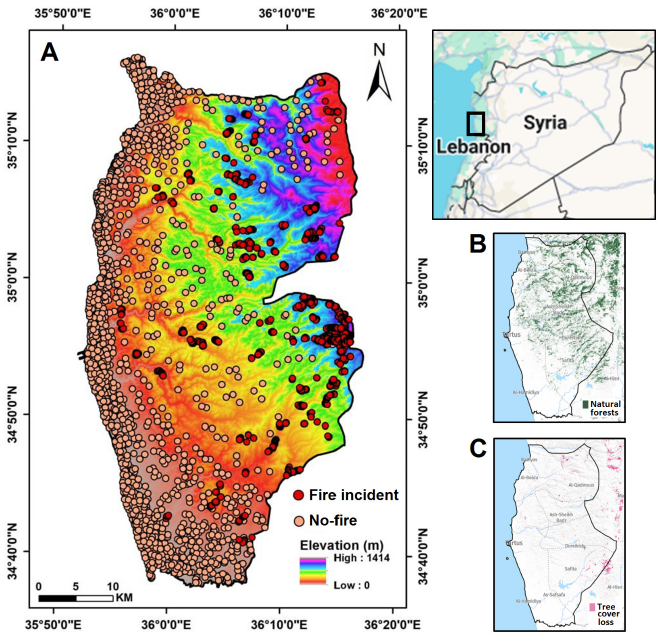
Tartous Governorate is situated in the western region of Syria, along the eastern Mediterranean coastline. Tartous ranks as the second most significant coastal region in Syria, following Latakia Governorate. The research site is situated between latitudes 35° 54ʹ and 36° 06ʹ North, and longitudes 35° 01ʹ and 35° 19ʹ East, covering a total area of 1919 km² (Fig. 1 A). The geographical boundaries of the study area include the Mediterranean Sea to the west, Homs and Hama Governorates to the east, Latakia Governorate to the north, and Lebanon to the south. The topographical and geomorphological diversity of Tartous Governorate is noteworthy. Mountains and plateaus comprise over 65% of the total area of the governorate. The northeastern region exhibits the highest elevation, measuring 1,414 meters above sea level. The research site exhibits a Mediterranean climate, characterized by summer temperatures surpassing 26°C and winter temperatures remaining above 11°C. The majority of the governorate experiences precipitation rates surpassing 800 mm. As reported by Global Forest Watch [20], the natural forests comprised 217 km² of the study area, accounting for 11.3% in the year 2020 (Fig. 1 B). The forests of Tartous represent a significant example of Mediterranean ecosystems, characterized by the presence of broadleaf species such as Oaks (Quercus sp.) alongside coniferous varieties including Aleppo pine (Pinus halepensis). Elevated regions are home to Cilician fir (Abies cilicica) and Lebanon cedar (Cedrus libani). Additional prevalent species encompass turpentine trees (Pistacia palaestina) and juniper (Juniperus excelsa). In 2024, a total of 41 hectares of natural forests were lost [20] due to forest fires and various deforestation activities (Fig. 1 C). Recent fires in 2025 are anticipated to contribute to a continued reduction in forest cover within the governate, highlighting the urgent need for the development of effective fire management strategies.
Forest fire inventory map
The creation of an inventory map for forest fire events serves as a foundational step in the development of susceptibility maps for forest fires. The fundamental basis for generating inventory maps of forest fires lies in the thorough examination of the exact spatial distribution of fire occurrences within forested areas, utilizing field studies, historical documentation, and high-resolution aerial and satellite imagery. This analysis delineates the spatial distribution of 1,500 forest fire occurrences recorded between 2017 and 2024, alongside the identification of 1,500 non-forest fire events.
Data acquisition
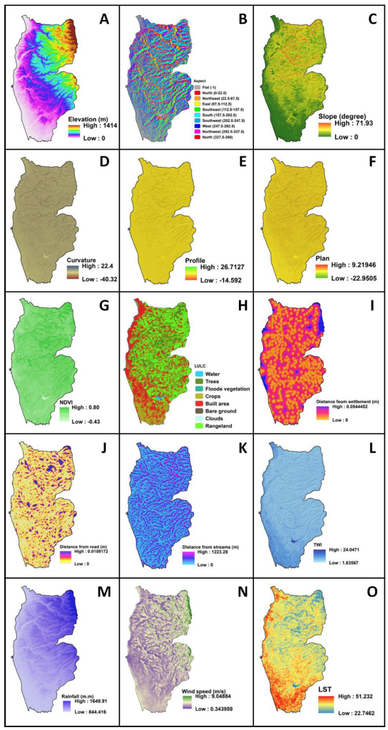
Forest fires are shaped by a multitude of natural, anthropogenic, and socio-economic variables. The present evaluation utilized information derived from multiple sources, encompassing remote sensing data, fieldwork observations, and data from official institutions. Satellite images (Landsat 8) and a digital elevation model (SRTM) were obtained from the USGS Earth Explorer website. Climate data (rainfall and wind speed) were used from the Damascus Meteorological Directorate. Data on roads, rivers, and settlements were taken from official data, including those from the Directorate of Transport and the Directorate of Water Resources in Tartous Governorate, and the General Organization for Remote Sensing in Syria (GORS). Overall, 15 environmental factors were selected: elevation, aspect, slope, curvature, profile, plan, topographic witness index (TWI), wind speed, rainfall, normalized difference vegetation index (NDVI), land use/land cover (LULC), distance to rivers, distance to roads, distance to settlements, and land surface temperature (LST). Then, a variety of GIS tools were employed to generate the maps illustrating the influencing factors (Fig. 2).
Multicollinearity test
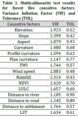
The multicollinearity test serves as a crucial statistical assessment that demonstrates the legitimacy of the parameters chosen for incorporation in the modeling procedure [22]. This examination focuses on identifying relationships among variables that result in erroneous and skewed results. The assessment of multicollinearity employs the methodologies of Variance Inflation Factor (VIF) and Tolerance (TOL). For the inclusion of all parameters in the modeling process, it is essential that the VIF value remains below 5 and the TOL value exceeds 0.1.
Important of causative factors
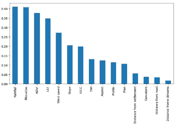
The Information Gain Ratio (IGR) test was used to assess the importance of environmental factors influencing forest fires. IGR is a statistical method based on information theory, used to measure how much each factor reduces the uncertainty associated with the occurrence of the studied phenomenon. This method calculates the amount of information gained by using each factor to classify the data and then adjusts this value using a “gain ratio” to avoid bias toward variables with many distinct values. This investigation involved the application of the test across all 15 factors to ascertain the most significant influences.
Machine learning algorithms
Machine learning (ML) algorithms represent a critical advancement in the toolkit employed worldwide for the analysis of various natural hazards. Furthermore, ML algorithms have been integrated with geographic information systems to forecast the vulnerability of wildfires across various ecosystems globally. This study presents a comparative analysis of the performance of four machine learning algorithms: Random Forest (RF), Support Vector Machine (SVM), Multi-Layer Perceptron (MLP), and K-Nearest Neighbors (KNN). For that purpose, the environmental factors passing multicollinearity test were considered as input, while the forest fire inventory was considered as an output in order to develop a comprehensive forest fire susceptibility map. In total, the dataset comprises 3000 data points, consisting of 1500 fire incidents and 1500 instances without fire. The dataset was divided into a training subset that constituted 70% of the total, with the remaining 30% designated for validation and testing activities.
Performance assessment of applied algorithms
In this analysis, several statistical criteria, including precision, recall, F1 score, accuracy and ROC-AUC, have been implemented to assess the efficiency and reliability of the used models:
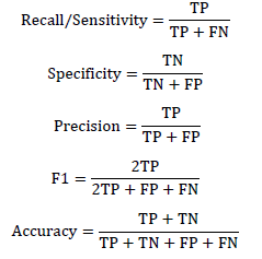
All these metrics are calculated using the values of different possible consequences (PC), namely false positive (FP), false negative (FN), true positive (TP), and true negative (TN). In the case of FP and FN, these wrongly classify the pixels of fire and no-fire, while TP and TN correctly classify the fire and no-fire locations.
Results and Discussion
Assessing the multicollinearity among chosen variables that affect a particular phenomenon is an essential step in accurately predicting the occurrence of this phenomenon. The multicollinearity assessment, incorporating the metrics of VIF (<5) and TOL (>0.1), confirmed the absence of overlap among the selected 15 factors (Table 1). Consequently, it is possible to incorporate all relevant factors into the analysis, leading to the generation of a susceptibility map for forest fires.
The analysis of importance (Fig. 3) underscores the significance of multiple factors affecting forest fires in the designated region, indicating that precipitation, altitude, and plant cover are the key components leading to an increase in forest fire occurrences. The variability observed in forest mass moisture values is significantly influenced by both precipitation (Fig. 2 M) levels and elevation (Fig. 2 A), which in turn intensifies their response to fire occurrences. This corresponds with the challenging topography of the study area, thereby resulting in heightened variability in the moisture levels of forest biomass [23][24]. Increased precipitation in winter can enhance the growth of vegetation, particularly in open regions of deforested areas. Such vegetation subsequently dries during the summer heat, resulting in an increased fire fuel load and a higher probability of larger and more intense fires. NDVI (Fig. 2 G) and LST (Fig. 2 O) were also significant contributors to fire susceptibility, which reflects vegetation health and thermal stress as critical factors for fuel flammability.
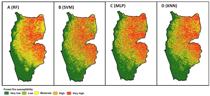
Forest fire susceptibility maps were developed utilizing four machine learning algorithms (Fig. 4). A consensus among all algorithms revealed that the northern, northeastern, and eastern regions exhibit high to very high susceptibility to forest fires. This observation aligns with the notable positive influence of elevation and precipitation on the frequency of forest fire occurrences.
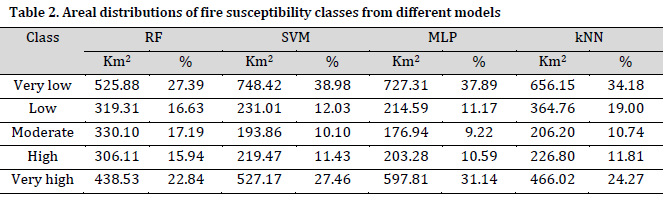
The quantitative analysis revealed a significant variation in the areal distribution of susceptibility classes across the different models (Table 2). All algorithms designated the most extensive regions within the Very Low fire susceptibility category, with areas spanning from 525.88 km² (27.39%) in RF to 748.42 km² (38.98%) in SVM. MLP assigned the highest Very High class proportion among the used algorithms (597.81 km²; 31.14%), followed by SVM (527.17 km²; 27.46%), KNN (466.02 km²; 24.27%) and RF (438.53 km²; 22.84%). A total of 38.78% of the study area was categorized as exhibiting High and Very High fire susceptibility zones based on RF analysis.
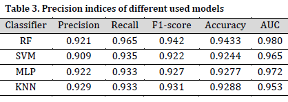
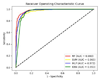
Regarding predictive performance, all four models exhibited significant accuracy and robustness (Table 3). The RF model demonstrated the highest overall accuracy of 94.33% and an AUC of 0.98 (Fig. 5), alongside precision, recall, and F1-score values of 0.921, 0.965, and 0.942, respectively. The MLP model demonstrated a commendable accuracy of 92.77% alongside an AUC value of 0.972. The support vector machine (SVM) demonstrated a marginally reduced performance, achieving an accuracy of 92.44% and an area under the curve (AUC) of 0.965. In contrast, the k-nearest neighbors (KNN) model displayed the highest precision at 0.929 and an F1-score of 0.931, despite recording the lowest AUC of 0.953 among the evaluated models. The findings suggest that although all models demonstrate effectiveness, RF provides the most balanced and precise predictive capability regarding forest fire susceptibility in this area.
The differences in susceptibility classification across the four models underscore the impact of algorithmic design on spatial results. The ensemble methodology employed by RF, which adeptly integrates feature significance and manages non-linear relationships [25], appears to have played a pivotal role in achieving enhanced performance metrics and consistent spatial patterns. The capacity to reduce overfitting and ensure consistent predictions renders it especially appropriate for intricate environmental modeling endeavors such as fire susceptibility assessment. This observation is corroborated by additional studies, which indicate that RF demonstrates a high level of reliability in assessing susceptibility to forest fires [26][27].
The identification of central-eastern and northern zones as high-risk across various models, particularly RF and MLP, highlights the convergence of several causal factors in these areas: steep slopes, south-facing aspects, proximity to settlements, and low vegetation density. The results presented here are consistent with earlier research that demonstrates the influence of topography, land use, and climatic factors on the dynamics of fire regimes [28].
The spatial outputs presented in this study yield practical insights for focused fire management strategies, including the prioritization of fuel breaks, community awareness initiatives, and early warning systems in designated areas of Very High susceptibility. The frequency of fire incidents in mountainous and inaccessible areas highlights the critical sensitivity and the urgent need for developing a comprehensive fire management plan for the region. Future research should incorporate temporal dynamics and ignition source data to improve predictive capabilities and bolster adaptive fire management strategies.
Conclusions
Forest fires represent a significant natural hazard that poses a serious threat to the sustainability of global ecosystems. In the western regions of Syria, specifically within the Tartous Governorate, there is a notable occurrence of frequent and intense wildfires annually affecting forest ecosystems. This research evaluated the efficacy of four machine learning algorithms—Random Forest (RF), Support Vector Machine (SVM), Multilayer Perceptron (MLP), and k-Nearest Neighbor (KNN)—in producing forest fire susceptibility maps based on 1,500 historical fire occurrences and 15 environmental factors. The findings demonstrated that the RF algorithm exhibited superior predictive accuracy compared to the other methods evaluated. Among the primary determinants, precipitation, altitude, and NDVI emerged as the most significant variables. The research introduces a comprehensive, evidence-based framework for spatially predicting forest fire risk, which can assist policymakers in executing focused forest management strategies and improving ecosystem resilience, particularly in the Eastern Mediterranean, in alignment with the objectives of Goals 13 and 15 of the UN Agenda 2030.
Conflict of interest statement
The authors declared no conflict of interest.
Funding statement
The authors declared that no funding was received in relation to this manuscript.
Data availability statement
The authors declared that all used data and data sources are mentioned in the manuscript. the used datasets will be available upon reasonable request from the corresponding author.
References
- Mishra M, Guria R, Baraj B, Nanda AP, Santos CAG, Silva RMD, Laksono FAT. Spatial analysis and machine learning prediction of forest fire susceptibility: a comprehensive approach for effective management and mitigation. Sci. Total Environ. 2024;926:171713. DOI
- Ma T, Wang G, Guo R, Chen L, Ma J. Forest fire susceptibility assessment under small sample scenario: A semi-supervised learning approach using transductive support vector machine. J. Environ. Manag. 2024;359:120966. DOI
- Zhao L, Ge Y, Guo S, Li H, Li X, Sun L, Chen J. Forest fire susceptibility mapping based on precipitation-constrained cumulative dryness status information in Southeast China: A novel machine learning modeling approach. For. Ecol. Manag. 2024;558:121771. DOI
- Tonbul H. Integrating ensemble machine learning and explainable AI for enhanced forest fire susceptibility analysis and risk assessment in Türkiye’s Mediterranean region. Earth Sci. Inform. 2024;17(6):5709-31. DOI
- Sarkar MS, Majhi BK, Pathak B, Biswas T, Mahapatra S, Kumar D, Bhatt ID, Kuniyal JC, Nautiyal S. Ensembling machine learning models to identify forest fire-susceptible zones in Northeast India. Ecol. Inform. 2024;81:102598. DOI
- Xie L, Zhang R, Lv J, Shama A, Yang Y. Enhancing forest fire susceptibility mapping in Xichang City, China using DBSCAN-based non-fire point selection integrated with deep neural network. Geomat. Nat. Hazards Risk. 2025;16(1):2443465. DOI
- United Nations. Transforming Our World: The 2030 Agenda for Sustainable Development; Resolution Adopted by the General Assembly on 25 September 2015; United Nations: New York, NY, USA, 2015;42809:1–13. (Accessed on 05/16/2025). Available from: Link
- Freitas KM, Juvanhol RS, Pinheiro CJG, Meneses AADM. Prediction of forest fire susceptibility using machine learning tools in the Triunfo do Xingu Environmental Protection Area, Amazon, Brazil. J. South Am. Earth Sci. 2025;153:105366. DOI
- Shi C, Zhang F. A Forest Fire Susceptibility Modeling Approach Based on Integration Machine Learning Algorithm. Forests. 2023;14(7):1506. DOI
- Ljubomir G, Pamučar D, Drobnjak S, Pourghasemi HR. Modeling the spatial variability of forest fire susceptibility using geographical information systems and the analytical hierarchy process. In: Spatial modeling in GIS and R for earth and environmental sciences. Elsevier. 2019:337-69. DOI
- Tiwari A, Shoab M, Dixit A. GIS-based forest fire susceptibility modeling in Pauri Garhwal, India: a comparative assessment of frequency ratio, analytic hierarchy process and fuzzy modeling techniques. Nat. Hazard. 2020;105(2):1189-230. DOI
- Esmali Ouri A, Golshan M, Jahdi R. Determining the forest fire susceptibility map in the Astara city using the Analytical Hierarchy Process (AHP) and Frequency Ratio Model (FR). Iran. J. For. Range Prot. Res. 2025;22(2):169-85. DOI
- Rihan M, Ali Bindajam A, Talukdar S, Shahfahad, Waseem Naikoo M, Mallick J, Rahman A. Forest fire susceptibility mapping with sensitivity and uncertainty analysis using machine learning and deep learning algorithms. Adv. Space Res. 2023;72(2):426-43. DOI
- Saha S, Bera B, Shit PK, Bhattacharjee S, Sengupta N. Prediction of forest fire susceptibility applying machine and deep learning algorithms for conservation priorities of forest resources. Remote Sens. Appl. Soc. Environ. 2023;29:100917. DOI
- Singha C, Swain KC, Moghimi A, Foroughnia F, Swain SK. Integrating geospatial, remote sensing, and machine learning for climate-induced forest fire susceptibility mapping in Similipal Tiger Reserve, India. For. Ecol. Manag. 2024;555:121729. DOI
- Zubkova M, Giglio L, Humber ML, Hall JV, Ellicott E. Conflict and Climate: Drivers of Fire Activity in Syria in the Twenty-First Century. Earth Interact. 2021;25(1):119-35. DOI
- Mitri G, Saba S, Nader M, McWethy D. Developing Lebanon’s fire danger forecast. Int. J. Disaster Risk Reduct. 2017;24:332-9. DOI
- Atasoy A, Geçen R. Forest Fires Occurred on Border Area between Turkey (Hatay) and Syria. Procedia – Social and Behavioral Sciences 2014;120:680-5. DOI
- Daiyoub A, Gelabert P, Saura-Mas S, Vega-Garcia C. War and Deforestation: Using Remote Sensing and Machine Learning to Identify the War-Induced Deforestation in Syria 2010–2019. Land. 2023;12(8):1509. DOI
- Global Forest Watch (GFW) online platform. 2024. (Accessed on 09/28/2025). Available from: Link
- Mohamed MA. An assessment of forest cover change and its driving forces in the syrian coastal region during a period of conflict, 2010 to 2020. Land. 2021;10(2):191. DOI
- Das J, Mahato S, Joshi PK, Liou Y. Forest Fire Susceptibility Zonation in Eastern India Using Statistical and Weighted Modelling Approaches. Remote Sens. 2023;15(5):1340. DOI
- Si L, Shu L, Wang M, Zhao F, Chen F, Li W, Li W. Study on forest fire danger prediction in plateau mountainous forest area. Nat. Hazard. Res. 2022;2(1):25-32. DOI
- Imran, Iqbal N, Ahmad S, Kim DH. Towards Mountain Fire Safety Using Fire Spread Predictive Analytics and Mountain Fire Containment in IoT Environment. Sustainability. 2021;13(5):2461. DOI
- Yaqoob A, Verma NK, Mir MA, Tejani GG, Eisa NHB, Mamoun Hussien Osman H, Shah MA. SGA-Driven feature selection and random forest classification for enhanced breast cancer diagnosis: A comparative study. Sci. Rep. 2025;15(1):10944. DOI
- Gao C, Lin H, Hu H. Forest-Fire-Risk Prediction Based on Random Forest and Backpropagation Neural Network of Heihe Area in Heilongjiang Province, China. Forests. 2023;14(2):170. DOI
- Akıncı HA, Akıncı H. Machine learning based forest fire susceptibility assessment of Manavgat district (Antalya), Turkey. Earth Sci. Inform. 2023;16(1):397-414. DOI
- Ruhil T, Singh H, Thapliyal M, Barthwal S. Cross-Border Collaborative Forest Fire Management: An Integrated Approach for Forest Fire Management in the Era of Climate Change. In: Forest Fire and Climate Change. Springer Nature Switzerland. 2025:263-77. DOI
Cite this article:
Richi,S. M.,Maya,R.,Ghribi,M. Forest fire susceptibility modeling in the Eastern Mediterranean: A machine learning assessment. DYSONA – Applied Science, 2026;7(1): 88-97. doi: 10.30493/das.2025.525949
