
Abed T. Jasim 1*
1, Department of Surveying Engineering, Technical Engineering College of Kirkuk, Northern Technical University, Kirkuk, Iraq
E-mail:
majid.abdulhameedl@uobasrah.edu.iq
Received: 13/09/2024
Acceptance: 18/10/2024
Available Online: 18/10/2024
Published: 01/01/2025

Manuscript link
http://dx.doi.org/10.30493/DAS.2024.478315
Abstract
A thorough examination of Land Use and Land Cover (LULC) changes is advantageous for environmental assessment and land management. The principal catalyst of this phenomena is human activity, particularly population expansion and the demand for increased urbanization. In this paper, Landsat imagery acquired from 2014 to 2022 was utilized to detect and classify alterations in land cover in Kirkuk City area. The Landsat images of the research region were analyzed employing two supervised classification techniques: the Maximum Likelihood Classification (MLC) algorithm and the Neural Network (NN) classification. Six specific signature classifications were chosen for categorization: water, bare land, soil, farm land, urban, and vegetation. The overall accuracy assessments of the MLC exceeded that of NN. The research findings revealed the substantial increase in agriculture and urban areas in Kirkuk city during the past few years. On the other hand, bare land and soil-covered regions has been reduced. These changes in land use are attributed to economic and population growth. The results of this study can significantly aid future urban planners in promoting sustainable urban development and protecting rural areas from random urbanization.
Keywords: LULC, Maximum likelihood classification, Land use, Kirkuk, Iraq
Introduction
The concern for Land Use and Land Cover (LULC) changes has emerged increasingly in the last few years for resource and environmental evaluation [1]. LULC can be an excellent indicator of human impact on the earth and environment [2]. Many other management activities including climate and bio-geochemistry modeling require a comprehensive evaluation of changes in land cover [3]. The geographical information is inconsistent, and contain tremendous amount of errors, which is a common issue in many growing nations, leading to the significant challenge of unplanned urbanization. Recent findings indicate significant expansion in the urban areas of Iraq, exemplified by Kirkuk City [4]. The city is heavily influenced by the broader trend of urbanization occurring in Iraq, driven by political instability, migration, mobilization, and population increase.
The assessment of remote sensing data for the purposes of land cover dynamics detection and monitoring is being widely considered in literature [5-9]. Researchers examining land cover alterations, such as deforestation, agricultural development, human settlement, and wetland encroachment, may find Landsat satellite images highly beneficial [10][11]. The most challenging aspect of this research is the direct detection and categorization of LULC utilizing medium-resolution Landsat remote sensing images.
The aims of this study were to classify and validate the types of land use and land cover (LULC) present, assess the magnitude and severity of the alterations, and to examine the factors that significantly influence land use and land cover change in Kirkuk City from 2014 to 2022.
Material and Methods
Study Area
Kirkuk (Fig. 1) is situated approximately 250 kilometers to the north of Baghdad, the capital of Iraq [12-14]. Kirkuk, Hawija, Daquq, and Dibis are the four districts that comprise the Kirkuk governorate. It encompasses a broad variety of topographies, from plains to valleys to mountainous locations. It is situated between the Hamrin Mountains to the south, the Zagros Mountains to the far north, the Zap and Tigris Rivers to the west, and the Sirwan River (Diyala) to the southwest [15].

Geography also plays a significant role in settlement patterns as towns grow near important industrial and agricultural areas. Kirkuk City for example has developed into one of the major cities centered on its strategic position and access to oil production areas.
Data, image processing, and analysis
Three Landsat satellite photos of Path/Row 169/35 were acquired from the USGS database, representing the evolving land use and land cover of Kirkuk City between 2014, 2018, and 2022 (Table 1)

The Supervised Maximum Likelihood Classification (MLC) and Neural Network (NN) classification techniques have been used to categorize data. For the signature classifications, six classes—namely, water, bare land, soil, agriculture, urban regions, and vegetation—were chosen. The photos were processed and analyzed using ENVI 5.3 software. Supervised categorization is necessary for this strategy to be implemented successfully. Thirty percent of the samples were utilized for evaluation and seventy percent were used for training. Random sampling has been used for accuracy evaluations. A small number of Ground Control Points (GCPs) were extracted, using field surveys and 1:250,000 scale Iraq toposheets, in order to evaluate the image accuracy (Fig. 2).

Change detection
Images from various satellites should be acquired simultaneously, using the same sensor, and at the same resolution in order to detect changes. Various techniques can be used to detect changes in landcover, such as multi-period cataloguing, image differencing, vegetation index differencing, major processes analysis, and transformation vector research [10][16][17]. Change detection is common application of post-classification comparison [18]. Using a pixel-by-pixel comparison method, each classified area may be identified to be experiencing a transition in landcover type [19]. After classification, Post-Classification has been applied on each image. For that purpose, the change detection statistics tool in the Envi software was employed by selecting and comparing classified images of 2014 and 2022.
Results
Accuracy assessment
In order to verify and test the classification, a total of 100 locations were visited throughout the studied region. Seventy percent of the samples (70 locations) were used for training, while thirty percent (30 locations) were utilized for evaluation. Between 2014 and 2022, the MLC and NN classifiers scored average classification accuracies of 96.10% and 94.59%, respectively. Despite no significant difference was observed between the two classifiers according paired t-test (p=0.08), MLC was superior on average and on yearly basis (Fig. 3). Therefore, MLC classifier was selected for LULC mapping in this study.

LULC classification
The land cover maps from 2014, 2018, and 2022 clearly indicate that “dense vegetation” occupies the western section of Kirkuk City (Fig. 4 A-C). Urban regions seem to remain rather stable over the research period, particularly within the city. Nonetheless, new urban developments and a noticeable expansion of urban areas are evident in the city and the rural regions to the west and south. An increase of roughly 36.6% and 31.1% in urban area was found in 2022 compared to 2014 and 2018, respectively (Fig. 4 D). Regions with soil coverage are predominantly located in the northern and southern sectors, with the majority utilized for agriculture and vegetation or turned into bare land in 2022 compared to 2014. Two separate soil sectors are seen in the northwestern and southeastern regions. The water status seems to have improved, with water-covered areas increasing from 0.5% in 2014 to 1.3% in 2018 and 1.6% in 2022 (Fig. 4 D). A considerable reduction in the continuity and overall expanse of bare land areas was recorded in 2018 relative to 2014 and 2022 (Fig. 4).

Change detection
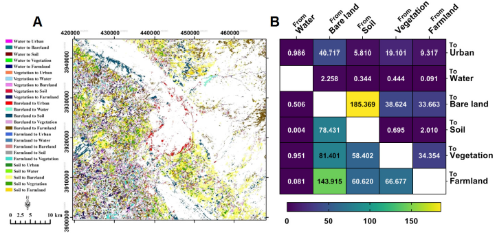
During the eight-year period from 2014 to 2022, the expansion of urban areas mostly occurred at the cost of barren land (40.72 km²), vegetation (19.1 km²), and agricultural land (9.32 km²). Conversely, as anticipated, the urbanized regions remained unchanged in classification. The change map indicates that the majority of urban growth in the city resulted from the conversion of bare land, as the city is encircled by it. The expansion of urban zones into bare land represents 53.6% of total new urban areas, while 37.4% of urban expansion was on the expense of farmland and vegetation zones (Fig. 5 B).
The most significant alteration was the transition from soil to barren areas (185.67 km²). These alterations were primarily seen in the southern and northern regions, with a few additional locations in the rural western areas (Fig. 5 A). Furthermore, 38.62 and 33.66 km² were converted from vegetation and agricultural land to barren ground. On the other hand, 225.32 km² were converted from barren terrain to vegetation and agricultural areas. Extensive areas were converted from farmland to vegetation zones and vice versa, indicating significant flexibility between both categories.
Discussion
In this work two classification models (MLC and NN) were compared in LULC mapping of Kirkuk City in 2014, 2018, and 2022. Both models scored above 90% classification accuracy on average. Machine learning algorithms are being employed in various environmental applications [20]. In this context, the model’s accuracy in LULC mapping using Landsat data should exceed 85%, with no class scoring less than 70% accuracy [21]. Therefore, both models are accurate enough for this task. Despite no significant differences were observed between two models, MLC was selected as the classifier for this study since it illustrated higher accuracy on average (96.10%) and on year to year basis.
Most newly established urban areas between 2014 and 2022 were situated on the bare land surrounding Kirkuk City. The encroachment of urban areas into the rural regions to the west and south has led to the degradation of vegetation and farmland, posing a substantial threat to regional agriculture, as 28.4 km² have been converted from vegetative and agricultural zones to urban development. These observations align with earlier research indicating that Kirkuk Governorate has lately seen significant urban expansion, resulting in many environmental, economic, and social challenges [22].
Alterations in land use and land cover (LULC) are essential for documenting environmental changes [23]. The study’s findings indicate that the studied region has seen significant alterations in land cover in response to land use changes, including urbanization, agricultural development, and the physical transformation of soil and plant cover. The observed tendency to convert bare land to urban and farmland zones indicates the importance of urbanization and agricultural production in the area. Other experts have also observed the recent development in the urban process and the increase in agricultural production in Kirkuk [24]. As these patterns may imply irreversible ecological and socioeconomic consequences, thorough planning and management of the environment, agriculture, and urban expansions is crucial. In this regard, the information derived from the remote sensing analysis is of paramount importance in determining land use patterns and trends, hence facilitating the development of urban and agricultural regions, among others [25]. Therefore, historical analysis of changes in land use and land cover dynamics, as well as the ability to forecast future changes, is highly relevant to support the identification of appropriate land use strategies. This data will support decision-makers to establish sustainable land use and development in the area.
Conclusion
The findings of the present study manifested a significant increase in the extent of the agricultural and urban land use in Kirkuk city while a corresponding decrease in the bare land and soil-covered areas was also observed. This underlines the need to use constant data acquired from the Landsat series to monitor LULC alterations. This situation requires policy intervention to ensure that the western rural regions of the city are protected and preserved as a hub of agricultural production; while the vast expanses of bare land to the east could be fully exploited to support a growing urban and production agenda.
References
- Kagabo AS, Safari B, Gasore J, Mutai BK, Sebaziga JN. Assessing the impact of Land Use Land Cover changes on land surface temperature over Kigali, Rwanda in the past three decades. Environ. Sustain. Indic. 2024;23:100452. DOI
- Sharma R, Nguyen TT, Grote U. Changing consumption patterns—Drivers and the environmental impact. Sustainability. 2018;10(11):4190. DOI
- Zhu Z, Woodcock CE. Continuous change detection and classification of land cover using all available Landsat data. Remote Sens. Environ. 2014;144:152–71. DOI
- Al-Janabi AHM, Azeez FH. Digital Technology in Urban Management and Spatial Development (Kirkuk City in Iraq-A Case Study). Evol. Stud. Imaginative Cult. 2024;1151–67.
- Mohammed J. Land use and cover change assessment using Remote Sensing and GIS: Dohuk City, Kurdistan, Iraq (1998–2011). Int. J. Geomatics. Geosci. 2013;3(3):552–69.
- Jumaah HJ, Ameen MH, Mohamed GH, Ajaj QM. Monitoring and evaluation Al-Razzaza lake changes in Iraq using GIS and remote sensing technology. Egypt. J. Remote Sens. Space Sci. 2022;25(1):313–21. DOI
- Jumaah HJ, Kalantar B, Ueda N, Sani OS, Ajaj QM, Jumaah SJ. The Effect of war on land use dynamics in Mosul Iraq using remote sensing and GIS techniques. In 2021 IEEE International Geoscience and Remote Sensing Symposium IGARSS. IEEE. 2021:6476–9. DOI
- Saed FG, Noori AM, Kalantar B, Qader WM, Ueda N. Earthquake‐Induced Ground Deformation Assessment via Sentinel‐1 Radar Aided at Darbandikhan Town. J. Sensors. 2022;2022(1):2020069. DOI
- Shareef MA, Hassan ND, Hasan SF, Noori AM. Integrating of GIS and fuzzy multi-criteria method to evaluate land degradation and their impact on the urban growth of Kirkuk city, Iraq. Int. J. Adv. Sci. Technol. 2019;28(15):800–15.
- Ajaj QM, Pradhan B, Noori AM, Jebur MN. Spatial monitoring of desertification extent in western Iraq using Landsat images and GIS. Land Degrad. Dev. 2017;28(8):2418–31. DOI
- Woodcock CE, Macomber SA, Pax-Lenney M, Cohen WB. Monitoring large areas for forest change using Landsat: Generalization across space, time and Landsat sensors. Remote Sens. Environ. 2001;78(1–2):194–203. DOI
- Hadi AM, Mohammed AK, Jumaah HJ, Ameen MH, Kalantar B, Rizeei HM, Al-Sharify ZT. GIS-based rainfall analysis using remotely sensed data in Kirkuk Province, Iraq: Rainfall analysis. Tikrit J. Eng. Sci. 2022;29(4):48-55. DOI
- Jumaah HJ, Jasim A, Rashid A, Ajaj Q. Air Pollution Risk Assessment Using GIS and Remotely Sensed Data in Kirkuk City, Iraq. J. Atmos. Sci. Res. 2023;6(3):41–51. DOI
- Jumaah HJ, Jasim AT, Hadi AM. Evaluation of Acid Rain Impacts Using Geostatistical Analysis and Remotely Sensed Data in Kirkuk City, Iraq: Evaluation of Acid Rain Impacts Using Geostatistical Analysis and Remotely Sensed Data in Kirkuk City, Iraq. Int. J. Econ. Environ. Geol. 2024;14(3):26–32. DOI
- Omar NQ, Ahamad MSS, Wan Hussin WMA, Samat N, Binti Ahmad SZ. Markov CA, multi regression, and multiple decision making for modeling historical changes in Kirkuk City, Iraq. J. Indian Soc. Remote Sens. 2014;42:165–78. DOI
- Mei A, Manzo C, Fontinovo G, Bassani C, Allegrini A, Petracchini F. Assessment of land cover changes in Lampedusa Island (Italy) using Landsat TM and OLI data. J African Earth Sci. 2016;122:15–24. DOI
- Mundia CN, Aniya M. Analysis of land use/cover changes and urban expansion of Nairobi city using remote sensing and GIS. Int. J. Remote Sens. 2005;26(13):2831–49. DOI
- Demarquet Q, Rapinel S, Gore O, Dufour S, Hubert-Moy L. Continuous change detection outperforms traditional post-classification change detection for long-term monitoring of wetlands. Int. J. Appl. Earth Obs. Geoinf. 2024;133:104142. DOI
- Poley AF, Bourgeau-Chavez LL, Graham JA, Vander Bilt DJ, Redhuis D, Battaglia MJ, Kennedy RE, French NH. Using Radiometric and Categorical Change to Create High-Accuracy Maps of Historical Land Cover Change in Watersheds of the Great Lakes Basin. Land. 2024;13(7):920. DOI
- Alsaeed RD, Alaji B, Ibrahim M. Predicting aluminium using full-scale data of a conventional water treatment plant on Orontes River by ANN, GEP, and DT. Int. J. Water. 2023;15(3):190-206. DOI
- Anderson JR. A land use and land cover classification system for use with remote sensor data. US Government Printing Office; 1976.
- Gehad TY, Omer NQ, Abdulmajeed NS. Methodology for Using Multi-Temporal Landsat Images to Monitor Urban Growth of Kirkuk Governorate. J. Tech. 2024;6(2):71-82. DOI
- Raj S, Rawat KS, Tripathi VK. Multi-Temporal Image Processing for LULC Classification and Change Detection. Env. Ecol. 2024;42:1349-57. DOI
- Abdula MA, Omar NQ. Ethnicity-based political decision making in urbanization using intelligent techniques by integrating GIS with remote sensing: A case study Kirkuk City, Iraq. In AIP Conference Proceedings. AIP Publishing. 2024. DOI
- Jamal Jumaah H, Adnan Rashid A, Abdul Razzaq Saleh S, Jamal Jumaah S. Deep Neural Remote Sensing and Sentinel-2 Satellite Image Processing of Kirkuk City, Iraq for Sustainable Prospective. J. Opt. Photonics Res. 2024. DOI
Cite this article:
Jasim, A. Assessing LULC dynamics in Kirkuk City, Iraq using Landsat imagery and maximum likelihood classification. DYSONA – Applied Science, 2024;6(1): 113-119. doi: 10.30493/das.2024.478315
