
Hazem G. Abdo 1*
1, Geography Department, Faculty of Arts and Humanities, University of Tartous, Tartous, Syria
E-mail:
hazemabdo@tartous-univ.edu.sy
Received: 18/06/2021
Acceptance: 08/11/2021
Available Online: 09/11/2021
Published: 01/01/2022

Manuscript link
http://dx.doi.org/10.30493/DAS.2021.311044
Abstract
Soil erosion is a serious global eco-threat to the sustainability of agricultural and ecological systems. In Syria, the issue of soil erosion represents a spatial challenge, especially during the last years of the war. The overall objective of this research is to assess the potential spatial distribution of the annual soil erosion rate in the Khawabi river basin in western Syria. The study relyed on the integration of multi-source data and the revised universal soil loss equation (RUSLE) in a geographic information system (GIS) environment. Soil erosion modeling inputs included the criteria of rainfall erosivity (R), soil erodibility (K), hill slope length and steepness (LS), and the vegetation factor (C). the annual rate of potential soil loss reached 35.86 ton ha-1 year-1 with a spatial average of 16.55 ton ha-1 year-1. The percentage of lands with high and very high erosion exposure was more than 29 % of the total area. Moreover, most of the lands of the study area exceeded the critical tolerance limits of erosion for the western Mediterranean regions (2 – 12-ton ha-1 year-1). The spatial outcomes of this study provided objective evidence that could support local environmental planners in the conservation and maintenance of soils in the studied basin.
Keywords: RUSLE, Erosion simulation, Land maintenance, Syria
Introduction
Soils are one of the most important components of the ecosystem that ensure global environmental, economic, and social sustainability [1]. In this context, the need for soil has increased in light of the rapid population growth and the expansion of related complex economic activities [2][3]. Soil loss is among the geomorphological risks that threaten agricultural and environmental systems [4-6]. Soil erosion causes damage to the surface soil structure, loss of organic matter and nutrients, and consequently, negatively impacts agricultural production [4].
In recent decades, the climate change and expansion of economic activities, primarily agricultural, industrial, and social, have added enormous pressures on the global land systems, thus effectively contributing to increasing the manifestations of land degradation, especially water erosion [7][8]. As relevant research indicates, the Mediterranean land systems are highly vulnerable to soil erosion events, especially in mountainous and hilly areas [9][10].
Recently, soil erosion has become one of the most prominent environmental problems that seriously threaten agricultural systems in the western region of Syria [8-10]. Soil erosion events in western Syria result from the spatial integration between the physical geographical factors, i.e. topography, precipitation, vegetation cover, and soil properties [11-13]. Moreover, human activities accelerate soil erosion, especially poor maintenance measures, agricultural intensification, population growth, urban expansion, and military actions [8][14-16].
Evaluating the spatial variability of water erosion risk in western Syria is crucial in planning urgent management strategies. Experimental mathematical models based on spatial techniques (GIS and RS), field measurements, and empirical mathematical models provide an effective tool with constructive outputs that enable the measurement of this problem [17-19]. Therefore, these empirical mathematical models have been widely used in the Mediterranean soil literature with promising results, especially the Coordination of Information on the Environment (CORINE) approach [11], Water Erosion Prediction Project (WEPP) model [20], and The Revised Universal Soil Loss Equation (RUSLE) method [10][12][14][19][21][22]. Based on the issue investigated above, the final objective of this research is the spatial integration of climate, soil properties, slope, and vegetation cover data to monitor the spatial distribution of potential soil erosion risk in western Syria (Al-Khawabi River Basin) using the RUSLE model by relying on field and RS data in a GIS environment.
Material and Methods
Study area
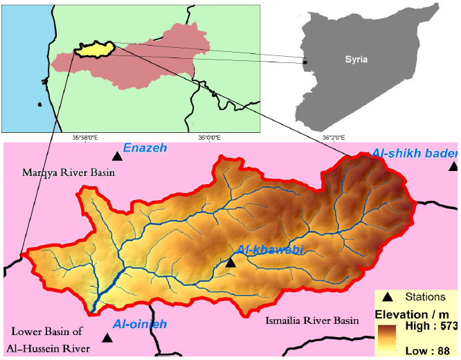
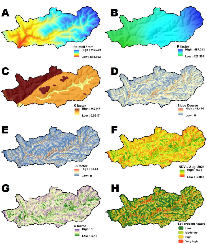
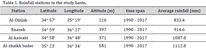
The Khawabi river basin is located in the western part of Syria, with an area of up to 25 km2 (Fig. 1). Geographically, the basin is bounded in the north by the Marqiya river basin, east and south by the Ismailia river basin, and west by the lower basin of the Al-Hussein river. The basin can be divided into two geomorphological sectors; the first constitutes the plateau region (88-400 m), while the second sector consists of the mountainous region (400-573). Climatically, the study basin is under the influence of the Mediterranean climate pattern, which is featured by hot and dry summers and mild and rainy winters with two volatile transitional seasons with 5-7 rainy months [6][23]. The annual average precipitation is 910 mm (Fig. 2 A), the average temperature in the summer is 23 °C, and in the winter is 14 °C, with an annual relative humidity of 75% [24].
RUSLE geo-factors
The universal equation of soil loss (RUSLE) [24] is one of the most used experimental mathematical models in investigating the annual rates of water erosion. RUSLE model is a global, hybrid, and flexible model that, in integration with GIS, provides objective and reliable outputs related to the assessment of the spatial distribution of soil erosion [25][26]. RUSLE model consists of five main spatial criteria given according to the following equation (Eq. 1):
A=R×K×LS×C×P (1)
where
- A: The average annual soil erosion (ton ha-1 year-1).
- R: Rainfall erosivity.
- K: Soil erodibility.
- LS: Hill slope length and steepness.
- C: The vegetation factor.
- P: The support practice.
Rainfall erosivity factor (R)
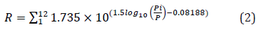
Rainfall erosivity factor (R) evaluates the effect of the kinetic energy of the raindrops with the generated surface runoff [14][27]. R factor is affected by the rainfall intensities, kinetic energy, and spatial comprehensiveness of precipitation [28]. The values of R factor were calculated according to the equation (Eq. 2) using the monthly averages of precipitation in four metrological stations during the period 1990 – 2017 (Fig. 1, Table 1),
where
- R: Rainfall erosivity factor (MJ mm ha_1 h_1 per year)
- Pi: Monthly rainfall (mm).
- P: The annual rainfall (mm).
Although the number of stations is insufficient, spatial interpolation tools in a GIS environment can provide reliable performance for mapping the spatial distribution of precipitation and R factor values [14]. Moreover, the principle of linear regression between the values of precipitation and R factors on the one hand, and the topographic elevation on the other hand, enables the process of mapping distributions more accurately [29]. R factor map was delineated (Fig. 2 B) using the inverse distance weighted (IDW) method. R factor ranged between 422.3 and 567.3 MJ mm ha-1 h-1 year-1.
Erodibility factor (K)
Soil erodibility factor (K) values reflect the resistance of soil particles to erosion by aqueous agents to their physical and chemical properties [12][28]. In other words, K factor monitors the effect of R parameter in increasing the sensitivity of soil structure to eroding and movement. In the current evaluation, the soil analysis results were obtained from the Beit-Kamouna Agricultural Center – Tartous Governorate. The K factor map was delineated in the GIS environment utilizing the following equation (Eq. 3) [24]:
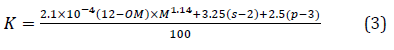
Where
- OM:Organic matter (%).
- s:Soil structure class.
- p:Permeability class.
- M: Aggregated variable derived from the granular soil texture:
M = (% Msilt) × (% Silt +% Sand)
Msilt is the modified silt which is the percentage of soil grain size between 0.002 and 0.1 mm. K Factor values fluctuated between 0.021 to 0.034 ton.ha.MJ-1.mm-1 (Fig. 2 C).
Slope factor (LS)
Slope factor (LS) represents the influence of the topographical variable on the increase of water erosion [9][30]. The relevant literature indicates that the slope variable is the most influential factor in increasing eroded soil amounts in Mediterranean areas [6][31][32]. Slope (Fig. 2 D) enhances the runoff energy, especially in the Mediterranean mountainous regions, characterized by high precipitation intensities [9][33]. At present assessment, the LS map was derived from the digital elevation model using the following equation (Eq. 4):
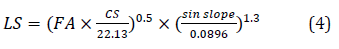
where
- FA: The grid layer of flow accumulation is expressed as the number of grid cells.
- CS: is the length of a cell side.
LS values of the investigated area were in the range of 0 – 49.41 (Fig. 2 E).
Vegetation factor (C)
Vegetation factor (C) investigates the effect of the presence of terrestrial and agricultural plant biomass on soil aggregation motility [14][34]. Vegetation cover is one of the most complex factors of soil erosion due to its significant impact in reducing the kinetic energy of raindrops, delaying the generation of runoff, and increasing permeability [11][35]. In the current study, the C factor map was derived using the Normalized difference vegetation index (NDVI) index, which is given by the following equation (Eq. 5):
NDVI = (NIR – RED) / (NIR + RED) (5)
where
NIR: Near-infrared band (band 4, ranging from 0.76 to 0.90 µm),
RED: Red band (band 3, ranging from 0.63 to 0.69 µm). Landsat 8 OLI image captured in August 2021 was used to calculate NDVI values ranging between -0.045 – 0.99 (Fig. 2 F). The values of C factor was calculated using the Eq. 6
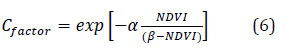
As the curve shape of the NDVI is determined by the parameters α and β. Reasonable results are produced using values of α = 2 and β = 1. C factor values ranged between – 0.18 – 1 (Fig. 2 G).
Conservation factor (P)
conservation practice factor (P) reflects the ratio of water erosion after a chosen backing procedure to the identical soil erosion after up and down cultivation [19][21]. P parameter modifies soil erosion rate by changing the flowing intensity, modifying the grade or direction of overland flow, and delaying the runoff generation [23]. P factor ranges from 0 to 1, the value 0 proposes perfect support exercises, and the value 1 proposes reduced conservation support exercises [24][36][37]. The field study implemented in the study area reveals the great poverty of maintenance and conservation measures, and therefore, a value of 1 was given to the P factor in the whole studied area.
Results and Discussion
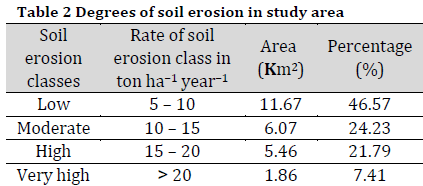
In the GIS environment (ArcGIS 10.2.3), the representative raster of RUSLE factors (i.e. R, K, LS, and C) was entered and subjected to the spatial modelling process in the Raster Calculator tool through spatial multiplication process. The spatial distribution of soil erosion susceptibility in the Khawabi river basin per hectare per year at cell level was visualized (Fig. 2 H). The results showed that the annual rate of potential soil loss reached 35.86 ton ha-1 year-1 with a spatial average of 16.55 ton ha-1 year-1. Moreover, the potential spatial hazards were classified into four grades: low (46.57 %), moderate (24.23 %), high (21.79 %), and very high (7.41 %) (Table. 2).
The high and very high values of potential erosion risk were distributed in the central and northwestern areas of the study basin. These areas are characterized by steep slopes, which positively affect the acceleration of erosion. In detail, the field studies carried out in the study area show that the slope factor is the most influential factor in the acceleration of erosion, especially in areas with low vegetation coverage. In this regard, the degree of slope in some locations is more than 45° (Fig. 2 D) and this causes a positive multiplier effect to increase the erosion rate.
Mediterranean studies indicate that the erosion tolerance threshold that ensures agricultural and economic sustainability ranges from 2 to 12 ton ha-1 year-1 [38-40]. Based on these erosion critical limits, it appears that most of the study area swiftly requires effective maintenance and soil conservation measures., especially that the traditionally applied maintenance procedures on these slopes increase the amount of soil eroded annually. Moreover, the population mainly depends on the cultivation of the slopes with many crops, especially olives, tobacco, and vegetables. In light of the scarce data, low funding, and the consequences of the current war in the country on the environmental and agricultural level, the present results make an objective contribution that will help local planners and decision makers in maintaining sectors of high and very high sensitivity to soil erosion.
Conclusion
Water erosion is a crucial threat with a high negative impact on agricultural sustainability in the western mountainous regions of Syria. In this study, the RUSLE model was used in combination with ground measurements and remote sensing data in a comprehensive spatial assessment of the soil’s sensitivity to erosion in the Khawabi river basin. The annual rate of potential soil loss reached 35.86 ton ha-1 year-1 with a spatial average of 16.55 ton ha-1 year-1. The percentage of areas with high and very high erosion sensitivity reached 29% of the study area. The current results prove the constructive potentials of the integration between the RUSLE model and the geographic information systems fed with the relevant terrestrial and spatial data in providing reliable and constructive spatial outputs that allow the start of the application of soil conservation procedures.
References
| 1 | Bezak N, Mikoš M, Borrelli P, Alewell C, Alvarez P, Anache JA, Baartman J, Ballabio C, Biddoccu M, Cerdà A, Chalise D. Soil erosion modelling: A bibliometric analysis. Environ. Res. 2021;197:111087. DOI |
| 2 | Mahala A. Soil erosion estimation using RUSLE and GIS techniques—a study of a plateau fringe region of tropical environment. Arab. J. Geosci. 2018;11(13):1-8. DOI |
| 3 | Borrelli P, Robinson DA, Fleischer LR, Lugato E, Ballabio C, Alewell C, Meusburger K, Modugno S, Schütt B, Ferro V, Bagarello V. An assessment of the global impact of 21st century land use change on soil erosion. Nat. Commun. 2017;8(1):1-3. DOI |
| 4 | Hateffard F, Mohammed S, Alsafadi K, Enaruvbe GO, Heidari A, Abdo HG, Rodrigo-Comino J. CMIP5 climate projections and RUSLE-based soil erosion assessment in the central part of Iran. Sci. Rep. 2021;11(1):1-7. DOI |
| 5 | Borrelli P, Alewell C, Alvarez P, Anache JA, Baartman J, Ballabio C, Bezak N, Biddoccu M, Cerdà A, Chalise D, Chen S. Soil erosion modelling: A global review and statistical analysis. Sci. Total Environ. 2021:146494. DOI |
| 6 | Mohammed S, Hassan E, Abdo HG, Szabo S, Mokhtar A, Alsafadi K, Al‐Khouri I, Rodrigo‐Comino J. Impacts of rainstorms on soil erosion and organic matter for different cover crop systems in the western coast agricultural region of Syria. Soil Use Manag. 2021;37(1):196-213. DOI |
| 7 | Li C, Li Z, Yang M, Ma B, Wang B. Grid-Scale Impact of Climate Change and Human Influence on Soil Erosion within East African Highlands (Kagera Basin). Int. J. Environ. Res. Public Health. 2021;18(5):2775. DOI |
| 8 | Mokhtar A, Jalali M, He H, Al-Ansari N, Elbeltagi A, Alsafadi K, Abdo HG, Sammen SS, Gyasi-Agyei Y, Rodrigo-Comino J. Estimation of SPEI Meteorological Drought Using Machine Learning Algorithms. IEEE Access. 2021;9:65503-23. DOI |
| 9 | Mohammed S, Abdo HG, Szabo S, Pham QB, Holb IJ, Linh NT, Anh DT, Alsafadi K, Mokhtar A, Kbibo I, Ibrahim J. Estimating human impacts on soil erosion considering different hillslope inclinations and land uses in the coastal region of Syria. Water. 2020;12(10):2786. DOI |
| 10 | Abdo H, Salloum J. Mapping the soil loss in Marqya basin: Syria using RUSLE model in GIS and RS techniques. Environ. Earth Sci. 2017;76(3):114. DOI |
| 11 | Khallouf A, Talukdar S, Harsányi E, Abdo HG, Mohammed S. Risk assessment of soil erosion by using CORINE model in the western part of Syrian Arab Republic. Agric. Food Secur. 2021;10(1):1-5. DOI |
| 12 | Abdo H, Salloum J. Spatial assessment of soil erosion in Alqerdaha basin (Syria). Model Earth Syst Environ. 2017;3(1):26. DOI |
| 13 | Djoukbala O, Hasbaia M, Benselama O, Mazour M. Comparison of the erosion prediction models from USLE, MUSLE and RUSLE in a Mediterranean watershed, case of Wadi Gazouana (NW of Algeria). Model Earth Syst Environ. 2019;5(2):725-43. DOI |
| 14 | Abdo HG. Impacts of war in Syria on vegetation dynamics and erosion risks in Safita area, Tartous, Syria. Reg. Environ. Change. 2018;18(6):1707-19. DOI |
| 15 | Zubkova M, Giglio L, Humber ML, Hall JV, Ellicott E. Conflict and Climate: Drivers of fire activity in Syria in the 21 st century. Earth Interact. 2021:1-48. DOI |
| 16 | Abdo HG. Assessment of landslide susceptibility zonation using frequency ratio and statistical index: a case study of Al-Fawar basin, Tartous, Syria. Int J Environ Sci Technol. 2021;154:1-20. DOI |
| 17 | Ganasri BP, Ramesh H. Assessment of soil erosion by RUSLE model using remote sensing and GIS-A case study of Nethravathi Basin. Geosci. Front 2016;7(6):953-61. DOI |
| 18 | Zerihun M, Mohammedyasin MS, Sewnet D, Adem AA, Lakew M. Assessment of soil erosion using RUSLE, GIS and remote sensing in NW Ethiopia. Geoderma regional. 2018;12:83-90. DOI |
| 19 | Abdo HG. Estimating water erosion using RUSLE, GIS and remote sensing in Wadi-Qandeel river basin, Lattakia, Syria. Proc. Indian National Sci. Acad. 2021;87(3):514–523. DOI |
| 20 | Safwan M, Alaa K, Omran A, Quoc BP, Nguyen TT, Van NT, Duong TA, Endre H. Predicting soil erosion hazard in Lattakia Governorate (W Syria). Int. J. Sediment Res. 2021;36(2):207-220. DOI |
| 21 | Almohamad H. Impact of Land Cover Change Due to Armed Conflicts on Soil Erosion in the Basin of the Northern Al-Kabeer River in Syria Using the RUSLE Model. Water. 2020;12(12):3323. DOI |
| 22 | Samanta S, Koloa C, Pal DK, Palsamanta B. Estimation of potential soil erosion rate using RUSLE and E 30 model. Model Earth Syst Environ. 2016;2(3). DOI |
| 23 | Abdo HG. Evolving a total-evaluation map of flash flood hazard for hydro-prioritization based on geohydromorphometric parameters and GIS–RS manner in Al-Hussain river basin, Tartous, Syria. Nat Hazards. 2020;104(1):681-703. DOI |
| 24 | Wischmeier WH, Smith DD. Predicting rainfall erosion losses: a guide to conservation planning. Department of Agriculture, Science and Education Administration. 1978. |
| 25 | Belayneh M, Yirgu T, Tsegaye D. Potential soil erosion estimation and area prioritization for better conservation planning in Gumara watershed using RUSLE and GIS techniques’. Environ. Res. 2019;8(1):1-7. DOI |
| 26 | Dissanayake DM, Morimoto T, Ranagalage M. Accessing the soil erosion rate based on RUSLE model for sustainable land use management: A case study of the Kotmale watershed, Sri Lanka. Model Earth Syst Environ. 2019;5(1):291-306. DOI |
| 27 | Abdo HG, Hassan RM. A statistical-spatial modeling of soil erosion: case study of Al-Sen basin,Tartous, Syria. J. Environ. Geol. 2018;2(2):68–74. |
| 28 | Zeng C, Wang S, Bai X, Li Y, Tian Y, Li Y, Wu L, Luo G. Soil erosion evolution and spatial correlation analysis in a typical karst geomorphology using RUSLE with GIS. Solid Earth. 2017;8(4):721-36. DOI |
| 29 | Alsafadi K, Mohammed S, Mokhtar A, Sharaf M, He H. Fine-resolution precipitation mapping over Syria using local regression and spatial interpolation. Atmos Res. 2021;256:105524. DOI |
| 30 | Abdo HG. Geo-modeling approach to predicting of erosion risks utilizing RS and GIS data: a case study of Al-Hussain Basin, Tartous, Syria. J. Environ. Geol. 2019;1(1):1–4. DOI |
| 31 | Kaffas K, Pisinaras V, Al Sayah MJ, Santopietro S, Righetti M. A USLE-based model with modified LS-factor combined with sediment delivery module for Alpine basins. CATENA. 2021;207:105655. DOI |
| 32 | Al Sayah MJ, Nedjai R, Kaffas K, Abdallah C, Khouri M. Assessing the Impact of Man–Made Ponds on Soil Erosion and Sediment Transport in Limnological Basins. Water. 2019;11(12):2526. DOI |
| 33 | Salloum J, Abdo H. The effectiveness of using digital elevation model in morphometric analysis of the network RiverAl-Mentar Basin. Tishreen Univ. J. Res. Sci. Stud. Arts Hum. Ser. 2015;37(4):421-39. |
| 34 | Yesuph AY, Dagnew AB. Soil erosion mapping and severity analysis based on RUSLE model and local perception in the Beshillo Catchment of the Blue Nile Basin, Ethiopia. Environ. Res. 2019;8(1):1-21. DOI |
| 35 | Salloum J, Abdo H. Statistical modeling of conservation the vegetation of the land in Alqadmous area from rainfall erosion. Tishreen Univ J Res Sci Stud-Arts Human Ser. 2016;38(3):667-83. |
| 36 | Ozsoy G, Aksoy E. Estimation of soil erosion risk within an important agricultural sub-watershed in Bursa, Turkey, in relation to rapid urbanization. Environ. Monit. Assess. 2015;187(7):1-4. DOI |
| 37 | Rellini I, Scopesi C, Olivari S, Firpo M, Maerker M. Assessment of soil erosion risk in a typical Mediterranean environment using a high resolution RUSLE approach (Portofino promontory, NW-Italy). J. Maps. 2019;15(2):356-62. DOI |
| 38 | Nearing MA, Deer-Ascough L, Laflen JM. Sensitivity analysis of the WEPP hillslope profile erosion model. Trans ASABE. 1990;33(3):839-49. DOI |
| 39 | Irvem A, Topaloğlu F, Uygur V. Estimating spatial distribution of soil loss over Seyhan River Basin in Turkey. J. Hydrol. 2007;336(1-2):30-7. DOI |
| 40 | Trabucchi M, Puente C, Comin FA, Olague G, Smith SV. Mapping erosion risk at the basin scale in a Mediterranean environment with opencast coal mines to target restoration actions. Reg. Environ. Change. 2012;12(4):675-87. DOI |
Cite this article:
Abdo, HG. Evaluating the potential soil erosion rate based on RUSLE model, GIS, and RS in Khawabi river basin, Tartous, Syria. DYSONA – Applied Science, 2022;1(1): 24-32. doi: 10.30493/das.2021.311044